
File:Lundy outline map.png

Size o this luikower: 504 × 600 pixels. Ither resolutions: 202 × 240 pixels | 600 × 714 pixels.
Oreeginal file (600 × 714 pixels, file size: 425 KB, MIME type: image/png)
Ootline
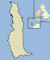
| Descreeption | A map of the Island of Lundy, in the Bristol Channel, part of the United Kingdom |
| Date | |
| Soorce | self-made, using Adobe Illustrator and Photoshop |
| Author | Jhamez84 |
Licensin
| I, the copyright holder of this work, release this work into the public domain. This applies worldwide. In some countries this may not be legally possible; if so: I grant anyone the right to use this work for any purpose, without any conditions, unless such conditions are required by law. |
File history
Clap oan ae date/time fer tae see the file aes it kithed at that time.
| Date/Time | Thummnail | Dimensions | Uiser | Comment | |
|---|---|---|---|---|---|
| current | 22:46, 17 October 2007 | | 600 × 714 (425 KB) | Jza84 | {{Information |Description=A map of the Island of Lundy, in the English Channel, part of the United Kingdom |Source=self-made, using Adobe Illustrator and Photoshop |Date=October 2007 |Author= Jhamez84 }} |
Eimage airtins
The follaein pages airts tae this image:
Global file uisage
The follaein ither wikis uise this file:
- Uisage on ar.wikipedia.org
- Uisage on ca.wikipedia.org
- Uisage on cs.wikipedia.org
- Uisage on de.wikipedia.org
- Uisage on en.wikipedia.org
- Uisage on en.wikivoyage.org
- Uisage on eo.wikipedia.org
- Uisage on es.wikipedia.org
- Uisage on eu.wikipedia.org
- Uisage on fi.wikipedia.org
- Uisage on fr.wikipedia.org
- Uisage on fr.wiktionary.org
- Uisage on ga.wikipedia.org
- Uisage on it.wikipedia.org
- Uisage on ja.wikipedia.org
- Uisage on ko.wikipedia.org
- Uisage on pl.wikipedia.org
- Uisage on pt.wikipedia.org
- Uisage on ru.wikipedia.org
- Uisage on uk.wikipedia.org
- Uisage on www.wikidata.org
- Uisage on zh.wikipedia.org