
File:LondonBrent.png
Nae heier resolution available.
LondonBrent.png (200 × 155 pixels, file size: 23 KB, MIME type: image/png)
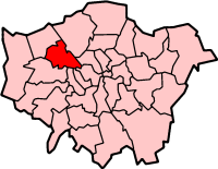
London Borough of Brent
Map drawn by en:User:Morwen

|
Permission is grantit tae copy, distribute an/or modify this document unner the terms o the GNU Free Documentation License, Version 1.2 or ony later version published bi the Free Software Foundation; wi no Invariant Sections, no Front-Cover Texts, an no Back-Cover Texts. A copy o the license is includit in the section enteetled GNU Free Documentation License. |
| This file is licensed unner the Creative Commons Attribution-Share Alike 3.0 Unported license. | ||
| ||
| This licensing tag was added to this file as part of the GFDL licensing update. |
File history
Clap oan ae date/time fer tae see the file aes it kithed at that time.
| Date/Time | Thummnail | Dimensions | Uiser | Comment | |
|---|---|---|---|---|---|
| current | 09:56, 9 Apryle 2005 | | 200 × 155 (23 KB) | Voyager | London Borough of Brent Map drawn by en:User:Morwen {{GFDL}} Category:Maps of London |
Eimage airtins
The follaein pages airts tae this image:
Global file uisage
The follaein ither wikis uise this file:
- Uisage on ar.wikipedia.org
- Uisage on da.wikipedia.org
- Uisage on en.wikipedia.org
- Alperton
- Brondesbury
- Cricklewood
- Harlesden
- Kensal Green
- Kenton, London
- Kilburn, London
- Kingsbury, London
- Neasden
- London Borough of Brent
- Wembley
- Willesden
- Dollis Hill
- Dollis Hill tube station
- Burnt Oak
- Wembley Park
- Colindale
- Queen's Park, London
- Paddock (war rooms)
- Parks and open spaces in the London Borough of Brent
- North Wembley
- Park Royal
- Sudbury, London
- Stonebridge, London
- Mapesbury
- Queensbury, London
- Brondesbury Park
- Preston, London
- Brent Park, Neasden
- Roe Green Park
- Template:LB Brent
- Tokyngton
- Fryent Country Park
- Category:London Borough of Brent
- List of public art in the London Borough of Brent
- St Raphael's Estate
- Church End, Brent
- Chalkhill Estate
- List of people from the London Borough of Brent
- The Library at Willesden Green
- Grade I and II* listed buildings in the London Borough of Brent
- Brent Civic Centre
- Wikipedia:WikiProject Navigation templates/Country subdivisions/United Kingdom/England
- London Designer Outlet
- User:Victor P./sandbox3
- Uisage on fr.wikipedia.org
View mair global usage o this file.