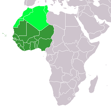
File:LocationWesternAfrica.png
LocationWesternAfrica.png (359 × 359 pixels, file size: 7 KB, MIME type: image/png)
File history
Clap oan ae date/time fer tae see the file aes it kithed at that time.
| Date/Time | Thummnail | Dimensions | Uiser | Comment | |
|---|---|---|---|---|---|
| current | 13:17, 11 November 2022 |  | 359 × 359 (7 KB) | ColorfulSmoke | . |
| 11:56, 11 November 2022 |  | 360 × 359 (7 KB) | ColorfulSmoke | ||
| 16:47, 17 Mairch 2018 |  | 360 × 392 (10 KB) | Maphobbyist | Upload | |
| 20:54, 31 Mairch 2016 |  | 360 × 392 (13 KB) | Fry1989 | Reverted to version as of 21:24, 9 July 2011 (UTC) | |
| 23:24, 15 Mairch 2016 |  | 360 × 392 (10 KB) | Hpyounes | new colors | |
| 21:24, 9 Julie 2011 |  | 360 × 392 (13 KB) | Maphobbyist | South Sudan has become independent on July 9, 2011. Sudan and South Sudan are shown with the new international border between them. | |
| 08:09, 11 December 2007 |  | 360 × 392 (14 KB) | Hoshie | added Cabinda (Angola) and Montenegro. | |
| 10:55, 5 Februar 2006 |  | 360 × 392 (8 KB) | E Pluribus Anthony~commonswiki | Map: Western Africa, including Maghreb (location) | |
| 19:52, 4 Februar 2006 |  | 360 × 392 (9 KB) | E Pluribus Anthony~commonswiki | Map: Western Africa, including Maghreb (location) |
Eimage airtins
The'r nae pages airts tae this eimage.
Global file uisage
The follaein ither wikis uise this file:
- Uisage on ab.wikipedia.org
- Uisage on ace.wikipedia.org
- Uisage on af.wikipedia.org
- Uisage on als.wikipedia.org
- Uisage on am.wikipedia.org
- Uisage on ar.wikipedia.org
- ليبيا
- جيبوتي
- موريتانيا
- تونس
- السودان
- الصحراء الغربية
- أنغولا
- أوغندا
- إسبانيا
- تشاد
- النيجر
- مالي
- السنغال
- غامبيا
- غينيا بيساو
- غينيا
- سيراليون
- ليبيريا
- غانا
- توغو
- بنين
- بوركينا فاسو
- الصومال
- كينيا
- تنزانيا
- الغابون
- زامبيا
- موزمبيق
- زيمبابوي
- البرتغال
- الكاميرون
- جمهورية الكونغو الديمقراطية
- بوتسوانا
- جنوب إفريقيا
- جمهورية إفريقيا الوسطى
- جمهورية الكونغو
- سيشل
- ناميبيا
View mair global usage o this file.


