
File:Kingdom of Mann and the Isles-en.svg

Size of this PNG preview of this SVG file: 571 × 600 pixels. Ither resolutions: 229 × 240 pixels | 457 × 480 pixels | 731 × 768 pixels | 975 × 1,024 pixels | 1,950 × 2,048 pixels | 1,297 × 1,362 pixels.
Oreeginal file (SVG file, nominallie 1,297 × 1,362 pixels, file size: 209 KB)
Ootline
| Descreeption |
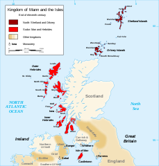
English: Map of the kingdom of Mann and the Isles, nearly the end of eleventh century.
Norðr: Shetland and Orkney
Sodor: Man and Hebrides Français : Carte du royaume de Man et des Îles, vers la fin du onzième siècle.
Norðr : Shetland et Orcades
Sodor : Man et Hebrides |
||
| Date | |||
| Soorce |
Own work based on: British Isles.svg, Mormaerdoms.png and Www.wesleyjohnston.com-users-ireland-maps-historical-map1014.gif |
||
| Author | Sémhur | ||
| Other versions |
Derivative works of this file: Kingdom of Mann and the Isles-es.svg
|
||
| Attribution (required by the license) | © Sémhur / Wikimedia Commons / | ||
| SVG | W3C-validity not checked.
|
||
| Atelier graphique |

| Camera location | | View this and other nearby images on: OpenStreetMap |
|---|
Licensin
I, the copyright holder of this work, hereby publish it under the following licenses:
| Copyleft: This wairk o airt is free; ye can redistreebute it n/or modifie it accordin til the terms o the Free Art License. Ye'll fynd ae specimen o this license oan the Copyleft Attitude steid aes weel aes oan ither steids. |
This file is licensed under the Creative Commons Attribution-Share Alike 3.0 Unported, 2.5 Generic, 2.0 Generic and 1.0 Generic license.
- Ye are free:
- tae share – tae copy, distribute an transmit the wirk
- tae remix – tae adapt the wirk
- Unner the follaein condeetions:
- attribution – Ye must attribute the wirk in the manner specified bi the author or licensor (but nae in ony way that suggests that thay endorse ye or yer uise o the wirk).
- share alik – If ye alter, transform, or big upon this wirk, ye mey distribute the resultin wirk anly unner the same or seemilar license tae this ane.
Ye mey select the license o yer choice.
File history
Clap oan ae date/time fer tae see the file aes it kithed at that time.
| Date/Time | Thummnail | Dimensions | Uiser | Comment | |
|---|---|---|---|---|---|
| current | 20:06, 26 December 2015 | | 1,297 × 1,362 (209 KB) | Alphathon | Various minor corrections/tweaks |
| 10:06, 15 October 2007 |  | 1,297 × 1,362 (208 KB) | Sémhur | {{Information |Description=Map of the kingdom of Mann and the Isles, nearly the end of eleventh century |Source=Own work, from : * Map of British Isles * [[:Image:Mormaerdoms.png|Map of kingdoms of Scotland in the Middle Ages] |
Eimage airtins
The'r nae pages airts tae this eimage.
Global file uisage
The follaein ither wikis uise this file:
- Uisage on af.wikipedia.org
- Uisage on be.wikipedia.org
- Uisage on bn.wikipedia.org
- Uisage on br.wikipedia.org
- Uisage on ca.wikipedia.org
- Uisage on cs.wikipedia.org
- Uisage on cy.wikipedia.org
- Uisage on da.wikipedia.org
- Uisage on de.wikipedia.org
- Uisage on el.wikipedia.org
- Uisage on en.wikipedia.org
- Hebrides
- Isle of Man
- History of the Isle of Man
- Norn language
- Scotland
- Outer Hebrides
- Kingdom of the Isles
- Slate Islands
- Diocese of Sodor and Man
- User:Jnestorius/Regions with significant island landmass
- Earldom of Orkney
- Thorfinn the Mighty
- List of early Germanic peoples
- Norse–Gaels
- Scotland in the High Middle Ages
- Portal:Middle Ages/Selected article
- Portal:Middle Ages/Selected article/10
- Manx runestones
- Viking expansion
- Kewish
- King of Mann
- List of active separatist movements in Europe
- Scottish island names
- Portal:Scotland/Selected article/2012
- Scandinavian Scotland
- Portal:Scotland/Selected article/Week 2, 2012
- Portal:Scotland/Selected article/2016
- Portal:Scotland/Selected article/Week 2, 2016
- Uisage on es.wikipedia.org
- Uisage on eu.wikipedia.org
View mair global usage o this file.