
File:Kensington and Chelsea London UK location map.svg

Size of this PNG preview of this SVG file: 563 × 600 pixels. Ither resolutions: 225 × 240 pixels | 450 × 480 pixels | 721 × 768 pixels | 961 × 1,024 pixels | 1,922 × 2,048 pixels | 1,188 × 1,266 pixels.
Oreeginal file (SVG file, nominallie 1,188 × 1,266 pixels, file size: 2.06 MB)
| Descreeption |
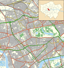
Location map of the Royal Borough of Kensington and Chelsea with the following information shown:
Equirectangular map projection on WGS 84 datum, with N/S stretched 160% Geographic limits:
|
| Date | |
| Soorce |
|
| Author | Nilfanion |
| Permission (Reuisin this file) |
This file is licensed unner the Creative Commons Attribution-Share Alike 3.0 Unported license. Attribution: Contains Ordnance Survey data © Crown copyright and database right
|
File history
Clap oan ae date/time fer tae see the file aes it kithed at that time.
| Date/Time | Thummnail | Dimensions | Uiser | Comment | |
|---|---|---|---|---|---|
| current | 23:11, 15 November 2011 | | 1,188 × 1,266 (2.06 MB) | Nilfanion | {{Information |Description=Location map of the Royal Borough of Kensington and Chelsea with the following information shown: *{{legend|#646464|Ward boundaries}} *{{legend|#667fff|Motorways}} *{{legend|#4cb336| |
Eimage airtins
The follaein pages airts tae this image:
Global file uisage
The follaein ither wikis uise this file:
- Uisage on ar.wikipedia.org
- Uisage on ceb.wikipedia.org
- Uisage on en.wikipedia.org
- Portobello Road
- Trellick Tower
- Design Museum
- Carlyle's House
- Leighton House Museum
- Royal Brompton Hospital
- Royal Marsden Hospital
- Cromwell Hospital
- Michelin House
- London Cage
- The Tower House
- Chelsea and Westminster Hospital
- Lister Hospital, Chelsea
- St Mary Abbots Hospital
- Restaurant Gordon Ramsay
- Allen Hall Seminary
- Module:Location map/data/United Kingdom London Kensington and Chelsea/doc
- The World's End, Chelsea
- Prince of Teck, Earl's Court
- The Hollywood Arms, Kensington
- Windsor Castle, Kensington
- Elgin, Ladbroke Grove
- Holland House
- Cadogan Pier
- Fox and Pheasant
- The King's Head and Eight Bells
- The Cross Keys, Chelsea
- The Phene
- The Hansom Cab
- Scarsdale Tavern
- Church of Our Most Holy Redeemer and St Thomas More, Chelsea
- Kensington Town Hall, London
- Chelsea Potter
- Zetland Arms
- The Goat, Kensington
- User:Chickstarr404/Gather lists/14617 – "Melbourne" by Lord David Cecil
- Goat, Chelsea
- Victoria Hospital for Children
- Gloucester Arms, Kensington
- The Greyhound, Kensington
- Anglesea Arms, South Kensington
- Bunch of Grapes, Knightsbridge
- Grenfell Tower fire
- Grenfell Tower
- Hollywood Road, Brompton
- Module:Location map/data/United Kingdom London Kensington and Chelsea
View mair global usage o this file.