
File:Japanese Empire (orthographic projection).svg

Size of this PNG preview of this SVG file: 600 × 600 pixels. Ither resolutions: 240 × 240 pixels | 480 × 480 pixels | 768 × 768 pixels | 1,024 × 1,024 pixels | 2,048 × 2,048 pixels.
Oreeginal file (SVG file, nominallie 600 × 600 pixels, file size: 665 KB)
Ootline
| Descreeption |
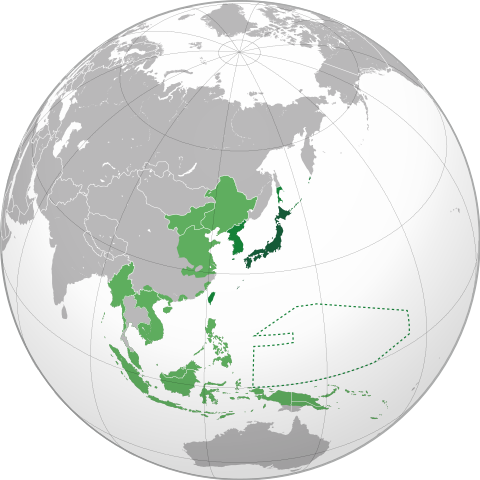
English: Japanese Empire.
Territory (1870–1895). Acquisitions (1895–1930). Acquisitions (1930–1942). South Seas Mandate (1919–1947). Español: Imperio Japonés.
Territorio (1870–1895). Adquisiciones (1895–1930) Adquisiciones (1930–1942). Mandato del Pacífico Sur (1919–1947). Українська: Японська імперія. Територія (1870–1895). Нові території (1895–1930). Нові території (1930–1942). Південний Тихоокеанський мандат (1919–1947). |
| Date | (UTC) |
| Soorce | |
| Author | Milenioscuro |
| Other versions |
.svg) |
| SVG genesis |
.svg)
.svg)
.svg)
.svg)
.svg)
.svg)
.svg)
.svg)
.svg)
.svg)
.svg)
.svg)
.svg)
.svg)
.svg)
.svg)
.svg)
.svg)
.svg)
.svg)
.svg)
.svg)
.svg)
.svg)
.svg)
.svg)
.svg)
.svg)
.svg)
.svg)
.svg)
.svg)
.svg)
.svg)
.svg)
.svg)
.svg)
.svg)
.svg)
.svg)
.svg)
.svg)
.svg)
.svg)
.svg)
.svg)
.svg)
.svg)
.svg)
.svg)
.svg)
.svg)
.svg)
.svg)
.svg)
.svg)
.svg)
.svg)
.svg)
.svg)
.svg)
.svg)
.svg)
.svg)
.svg)
.svg)
.svg)
.svg)
.svg)
.svg)
.svg)
.svg)
.svg)

.svg)

.svg)

.svg)
.svg)
.svg)
.svg)
.svg)
.svg)
.svg)


.svg)
.svg)
.svg)
.svg)
.svg)
.svg)
.svg)

.svg)
.svg)
.svg)
.svg)
.svg)
.svg)
.svg)
.svg)
.svg)

.svg)
.svg)
.svg)
.svg)
.svg)
.svg)
.svg)
_without_national_boundaries.svg)
.svg)
.svg)
.svg)
.svg)
.svg)
.svg)

.svg)
.svg)
.png)
.svg)
.svg)
.svg)
.svg)

.svg)
.svg)
.svg)
.svg)
.svg)
.svg)
.svg)
.svg)
.svg)
.svg)
.svg)

.svg)
.svg)
.svg)
.svg)
.svg)
.svg)
.svg)
.svg)
.svg)

.svg)
.svg)

.svg)
.svg)
.svg)
.svg)
.svg)
.svg)
.svg)
.svg)
.svg)
.svg)
.svg)
.svg)
.svg)
.svg)
.svg)
.svg)
.svg)
.svg)
.svg)
.svg)
.svg)
.svg)
.svg)
.svg)
.svg)
.svg)
.svg)
_-_Crimea_disputed.svg)
.svg)
.svg)
.svg)
.svg)
.svg)
.svg)
.svg)
.svg)
.svg)
.svg)
.svg)
_political.svg)
.svg)
.svg)
.svg)
.svg)
_-_Crimea_disputed_-_no_borders.svg)
.svg)
.svg)
.svg)
.svg)
.svg)
.svg)
.svg)
.svg)
.svg)
.svg)
.svg)

.svg)
.svg)
.svg)

.png)
.svg)
.svg)
.svg)
.svg)
.svg)
.svg)
.svg)
.svg)
.svg)
.svg)
.svg)
.svg)
.svg)
.svg)
.svg)
.svg)
.svg)
.svg)
.svg)
.svg)
.svg)
.svg)
.svg)
.svg)
.svg)
.svg)
.svg)
.svg)
.svg)
.svg)
.svg)
.svg)
.svg)
.svg)
.png)
.svg)
.svg)
.svg)
_(orthographic_projection).png)
.svg)
Licensin
I, the copyright holder of this work, hereby publish it under the following licenses:

|
Permission is grantit tae copy, distribute an/or modify this document unner the terms o the GNU Free Documentation License, Version 1.2 or ony later version published bi the Free Software Foundation; wi no Invariant Sections, no Front-Cover Texts, an no Back-Cover Texts. A copy o the license is includit in the section enteetled GNU Free Documentation License. |
This file is licensed unner the Creative Commons Attribution-Share Alike 3.0 Unported license.
- Ye are free:
- tae share – tae copy, distribute an transmit the wirk
- tae remix – tae adapt the wirk
- Unner the follaein condeetions:
- attribution – Ye must attribute the wirk in the manner specified bi the author or licensor (but nae in ony way that suggests that thay endorse ye or yer uise o the wirk).
- share alik – If ye alter, transform, or big upon this wirk, ye mey distribute the resultin wirk anly unner the same or seemilar license tae this ane.
Ye mey select the license o yer choice.
Original upload log
This image is a derivative work of the following images:
- File:Japan (orthographic projection).svg licensed with Cc-by-sa-3.0, GFDL
Uploaded with derivativeFX
File history
Clap oan ae date/time fer tae see the file aes it kithed at that time.
.svg&dir=prev)
.svg&offset=20200705200804)
.svg&offset=&limit=20)
.svg&offset=&limit=50)
.svg&offset=&limit=100)
.svg&offset=&limit=250)
.svg&offset=&limit=500)
| Date/Time | Thummnail | Dimensions | Uiser | Comment | |
|---|---|---|---|---|---|
| current | 03:45, 14 Juin 2023 | | 600 × 600 (665 KB) | Banklive | Reverted to version as of 04:21, 2 May 2022 (UTC) treaty between thailand and japan 1940. The treaty should be used as a reference. The same standard as Switzerland in Europe. |
| 14:54, 21 Apryle 2023 |  | 600 × 600 (797 KB) | LCJapan2034 | Reverted to version as of 19:32, 15 June 2021 (UTC) | |
| 04:21, 2 Mey 2022 |  | 600 × 600 (665 KB) | TheMysteriousStar | Reverted to version as of 12:51, 14 June 2021 (UTC) Japan never controlled Thailand | |
| 19:32, 15 Juin 2021 |  | 600 × 600 (797 KB) | Milenioscuro | Reverted to version as of 21:19, 16 April 2021 (UTC) | |
| 12:51, 14 Juin 2021 |  | 600 × 600 (665 KB) | Commymono | Reverted to version as of 11:13, 23 January 2015 (UTC) | |
| 21:19, 16 Apryle 2021 |  | 600 × 600 (797 KB) | Milenioscuro | corrected size of Dalian/Port Arthur | |
| 21:42, 14 November 2020 |  | 600 × 600 (847 KB) | Milenioscuro | resolving some really, really, REALLY bad editions of this guys | |
| 16:19, 6 August 2020 |  | 600 × 600 (1.37 MB) | Hell - lllio | better borders, added christimas, spratly and paracel islands. | |
| 18:07, 6 Julie 2020 |  | 600 × 600 (1.24 MB) | Hell - lllio | Fixed Borders in South Yunnan, added Guam, Bonin Islands, Volcano Islands, Wake Islands, Gilbert Islands, Minami-Tori-shima, Okinotorishima and Pescadores. | |
| 20:08, 5 Julie 2020 |  | 600 × 600 (1.24 MB) | Hell - lllio | added Thailand (Under Massive Japanese Influence), Attu and Kiska (Aleutian Islands Campaign) and Parts on the South of the Yunnan Region. |
Eimage airtins
The follaein pages airts tae this image:
Global file uisage
The follaein ither wikis uise this file:
- Uisage on af.wikipedia.org
- Uisage on ar.wikipedia.org
- Uisage on arz.wikipedia.org
- Uisage on ast.wikipedia.org
- Uisage on azb.wikipedia.org
- Uisage on az.wikipedia.org
- Uisage on be.wikipedia.org
- Uisage on bg.wikipedia.org
- Uisage on bjn.wikipedia.org
- Uisage on bn.wikipedia.org
- Uisage on br.wikipedia.org
- Uisage on bxr.wikipedia.org
- Uisage on ca.wikipedia.org
- Uisage on cdo.wikipedia.org
- Uisage on cs.wikipedia.org
- Uisage on cy.wikipedia.org
- Uisage on da.wikipedia.org
- Uisage on de.wikipedia.org
- Uisage on el.wikipedia.org
- Uisage on en.wikipedia.org
View mair global usage o this file.
.svg)
.svg)