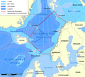
File:Europäisches Nordmeer mit Grenzen.png

Size o this luikower: 658 × 599 pixels. Ither resolutions: 263 × 240 pixels | 527 × 480 pixels | 989 × 901 pixels.
Oreeginal file (989 × 901 pixels, file size: 441 KB, MIME type: image/png)
File history
Clap oan ae date/time fer tae see the file aes it kithed at that time.
| Date/Time | Thummnail | Dimensions | Uiser | Comment | |
|---|---|---|---|---|---|
| current | 03:58, 10 December 2012 |  | 989 × 901 (441 KB) | Ras67 | cropped |
| 18:18, 12 December 2010 |  | 1,000 × 913 (560 KB) | PaterMcFly | Location of North Cape fixed. Got confused about the map projection. | |
| 17:05, 12 December 2010 |  | 1,000 × 913 (561 KB) | PaterMcFly | Minor corrections (borders drawn a bit more precisely, see my dewiki talk page) | |
| 13:02, 1 Mey 2009 |  | 1,000 × 913 (561 KB) | Urdangaray | {{Information |Description={{de|de:Europäisches Nordmeer mit Grenzen und Tiefenangaben}} |Source=Transferred from [http://de.wikipedia.org de.wikipedia]<br/> (Original text : ''Aus de::Bild:Karte Europäisches Nordmeer.png selbst gebastelt. Q |
Eimage airtins
The'r nae pages airts tae this eimage.
Global file uisage
The follaein ither wikis uise this file:
- Uisage on af.wikipedia.org
- Uisage on ast.wikipedia.org
- Uisage on azb.wikipedia.org
- Uisage on az.wikipedia.org
- Uisage on ba.wikipedia.org
- Uisage on bg.wikipedia.org
- Uisage on br.wikipedia.org
- Uisage on ce.wikipedia.org
- Uisage on da.wikipedia.org
- Uisage on de.wikipedia.org
- Uisage on de.wiktionary.org
- Uisage on en.wikipedia.org
- Uisage on en.wikiversity.org
- Uisage on en.wiktionary.org
- Uisage on eo.wikipedia.org
- Uisage on es.wikipedia.org
- Uisage on fi.wikipedia.org
- Uisage on frr.wikipedia.org
- Uisage on fy.wikipedia.org
- Uisage on gl.wikipedia.org
- Uisage on hr.wikipedia.org
- Uisage on id.wikipedia.org
- Uisage on ilo.wikipedia.org
- Uisage on ja.wikipedia.org
- Uisage on kn.wikipedia.org
- Uisage on la.wikipedia.org
- Uisage on li.wikipedia.org
- Uisage on lv.wikipedia.org
- Uisage on mg.wikipedia.org
- Uisage on mk.wikipedia.org
- Uisage on ml.wikipedia.org
- Uisage on ms.wikipedia.org
- Uisage on nl.wikipedia.org
- Uisage on no.wikipedia.org
View mair global usage o this file.

