File:Etruscan civilization map.png

Page contents not supported in other languages.
Frae Wikipedia, the free beuk o knawledge

Oreeginal file(994 × 1,208 pixels, file size: 361 KB, MIME type: image/png)

This file is fae Wikimedia Commons n micht be uised bi ither waurks. The descreeption oan its file descreeption page thaur is shawn ablo.

Ootline

Descreeption

[eedit]

If you can, help make this description accessible to all by translating it into other languages. – Thanks!
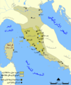
Català: Un mapa que mostra l'extensió d'Etruria i la civilització etrusca. El mapa inclou les 12 ciutats de la Lliga Etrusca i ciutats notables fundades pels etruscs. Les dates del mapa són una aproximació.
English: A map showing the extent of Etruria and the Etruscan civilization. The map includes the 12 cities of the Etruscan League and notable cities founded by the Etruscans. The dates on the map are an approximation.
Español: Expansión etrusca entre el 750 y el 500 a. de C., las ciudades de la Liga etrusca y otras notables fundadas por los etruscos.
Português: Mapa da expansão etrusca entre 750-500
Suomi: Kartta Etruriasta ja etruskien sivilisaatiosta sen ollessa laajimmillaan. Karttaan on merkitty etruskien kaupunkiliiton 12 kaupunkia sekä muita etruskien perustamia merkittäviä kaupunkeja.
Ελληνικά: Χάρτης της Ετρουρίας
Беларуская: Карта паказвае абрысы Этрурыі і этрускай цывілізацыі. Яна ўключае 12 асноўных гарадоў этрускай лігі і іншыя горады, заснаваныя этрускамі.
ქართული: ეტრუსკული ცივილიზაციის რუკა.
עברית : מפה המציגה את היקף אטרוריה והציוויליזציה האטרוסקית. המפה כוללת את 12 ערי הליגה האטרוסקית וערים בולטות שנוסדו על ידי האטרוסקים. התאריכים במפה הם בקירוב.
العربية : خريطة تُظهر نطاق الحضارتين الإترورياويَّة والإتروسكانيَّة. تتضمَّن هذه الخريطة 12 مدينة انتمت إلى الرابطة الإتروسكانيَّة ومُدن مُهمَّة وبارزة أُخرى كانت قائمة ضمن بلاد الإتروسكان.
Date
Soorce Based on a map from The National Geographic Magazine Vol.173 No.6 June 1988.
Author NormanEinstein
Permission
(Reuisin this file)
GNU-FDL
Other versions

[eedit]


This historical map image could be re-created using vector graphics as an SVG file. This has several advantages; see Commons:Media for cleanup for more information. If an SVG form of this image is available, please upload it and afterwards replace this template with {{vector version available|new image name}}.


It is recommended to name the SVG file “Etruscan civilization map.svg”—then the template Vector version available (or Vva) does not need the new image name parameter.

Licensin

I, the copyright holder of this work, hereby publish it under the following licenses:
GNU head Permission is grantit tae copy, distribute an/or modify this document unner the terms o the GNU Free Documentation License, Version 1.2 or ony later version published bi the Free Software Foundation; wi no Invariant Sections, no Front-Cover Texts, an no Back-Cover Texts. A copy o the license is includit in the section enteetled GNU Free Documentation License.
w:en:Creative Commons
attribution share alik
This file is licensed unner the Creative Commons Attribution-Share Alike 3.0 Unported license.
Ye are free:
  • tae share – tae copy, distribute an transmit the wirk
  • tae remix – tae adapt the wirk
Unner the follaein condeetions:
  • attribution – Ye must attribute the wirk in the manner specified bi the author or licensor (but nae in ony way that suggests that thay endorse ye or yer uise o the wirk).
  • share alik – If ye alter, transform, or big upon this wirk, ye mey distribute the resultin wirk anly unner the same or seemilar license tae this ane.
This licensing tag was added to this file as part of the GFDL licensing update.
Ye mey select the license o yer choice.

Captions

Add a one-line explanation of what this file represents
Map showing the extent of Etruria and the Etruscan civilization and the twelve Etruscan League cities.

Items portrayed in this file

depicts

File history

Clap oan ae date/time fer tae see the file aes it kithed at that time.

Date/TimeThummnailDimensionsUiserComment
current12:18, 22 Julie 2010Thumbnail fer version aes o 12:18, 22 Julie 2010994 × 1,208 (361 KB)Ras67cropped
20:10, 6 Februar 2006Thumbnail fer version aes o 20:10, 6 Februar 20061,000 × 1,214 (525 KB)NormanEinsteinModified tribe names.
14:01, 27 Julie 2005Thumbnail fer version aes o 14:01, 27 Julie 2005800 × 971 (405 KB)NormanEinsteinCorrected several typos.
21:03, 26 Julie 2005Thumbnail fer version aes o 21:03, 26 Julie 2005800 × 971 (416 KB)NormanEinsteinA map showing the extent of Etruria and the Etruscan civilization. The map includes the 12 cities of the Etruscan League and notable cities founded by the Etruscans. Created by NormanEinstein, July 26, 2005. {{GFDL-self}}

The follaein pages airts tae this image:

Global file uisage

The follaein ither wikis uise this file:

View mair global usage o this file.