
File:Elgin Castle - geograph.org.uk - 366911.jpg
Nae heier resolution available.
Elgin_Castle_-_geograph.org.uk_-_366911.jpg (640 × 392 pixels, file size: 217 KB, MIME type: image/jpeg)
Ootline
| Descreeption |
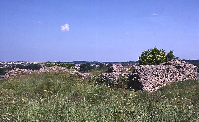
English: Elgin Castle These piles of rubble are the remains of what was once Elgin Castle. It stood on the top of Lady Hill, dominating the town. It met the same fate as many another mediaeval Scottish Castle; King Robert the Bruce could not afford the men to garrison it after capturing it from the English, so he had them tear it down to prevent the enemy re-occupying it. |
| Date | |
| Soorce | From geograph.org.uk |
| Author | Anne Burgess |
| Attribution (required by the license) | Anne Burgess / Elgin Castle / |
| Camera location | | View this and other nearby images on: OpenStreetMap |
|---|
_heading:67.00&language=sco)
| Object location | | View this and other nearby images on: OpenStreetMap |
|---|
_heading:67.00&language=sco)
Licensin

|
This image was taken from the Geograph project collection. See this photograph's page on the Geograph website for the photographer's contact details. The copyright on this image is owned by Anne Burgess and is licensed for reuse under the Creative Commons Attribution-ShareAlike 2.0 license.
|
This file is licensed under the Creative Commons Attribution-Share Alike 2.0 Generic license.
Attribution: Anne Burgess
- Ye are free:
- tae share – tae copy, distribute an transmit the wirk
- tae remix – tae adapt the wirk
- Unner the follaein condeetions:
- attribution – Ye must attribute the wirk in the manner specified bi the author or licensor (but nae in ony way that suggests that thay endorse ye or yer uise o the wirk).
- share alik – If ye alter, transform, or big upon this wirk, ye mey distribute the resultin wirk anly unner the same or seemilar license tae this ane.
File history
Clap oan ae date/time fer tae see the file aes it kithed at that time.
| Date/Time | Thummnail | Dimensions | Uiser | Comment | |
|---|---|---|---|---|---|
| current | 17:04, 4 Januar 2011 | | 640 × 392 (217 KB) | GeographBot | == {{int:filedesc}} == {{Information |description={{en|1=Elgin Castle These piles of rubble are the remains of what was once Elgin Castle. It stood on the top of Lady Hill, dominating the town. It met the same fate as many another mediaeval Scottish Castl |
Eimage airtins
The'r nae pages airts tae this eimage.
Global file uisage
The follaein ither wikis uise this file:
- Uisage on de.wikipedia.org
- Uisage on de.wikivoyage.org
- Uisage on en.wikipedia.org
- Uisage on it.wikipedia.org
- Uisage on pt.wikipedia.org
- Uisage on www.wikidata.org