
File:East Sussex UK locator map 2010.svg

Size of this PNG preview of this SVG file: 494 × 600 pixels. Ither resolutions: 198 × 240 pixels | 395 × 480 pixels | 633 × 768 pixels | 843 × 1,024 pixels | 1,687 × 2,048 pixels | 1,108 × 1,345 pixels.
Oreeginal file (SVG file, nominallie 1,108 × 1,345 pixels, file size: 302 KB)
Ootline
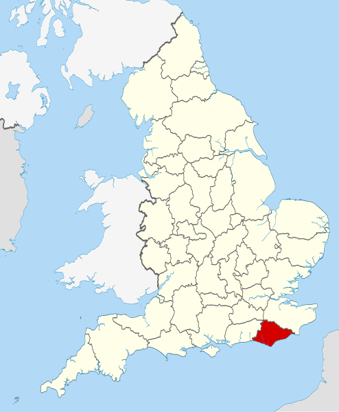
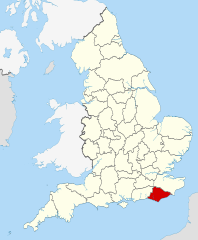
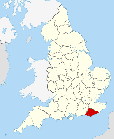
| Descreeption | Location of the ceremonial county of East Sussex within England. |
| Date | |
| Soorce |
National Geospatial-Intelligence Agency
|
| Author | Nilfanion |
Licensin
I, the copyright holder of this work, hereby publish it under the following licenses:
This file is licensed unner the Creative Commons Attribution-Share Alike 3.0 Unported license.
- Ye are free:
- tae share – tae copy, distribute an transmit the wirk
- tae remix – tae adapt the wirk
- Unner the follaein condeetions:
- attribution – Ye must attribute the wirk in the manner specified bi the author or licensor (but nae in ony way that suggests that thay endorse ye or yer uise o the wirk).
- share alik – If ye alter, transform, or big upon this wirk, ye mey distribute the resultin wirk anly unner the same or seemilar license tae this ane.

|
Permission is grantit tae copy, distribute an/or modify this document unner the terms o the GNU Free Documentation License, Version 1.2 or ony later version published bi the Free Software Foundation; wi no Invariant Sections, no Front-Cover Texts, an no Back-Cover Texts. A copy o the license is includit in the section enteetled GNU Free Documentation License. |
Ye mey select the license o yer choice.

|
This is one of the images forming part of the Valued image set: Locator maps of the Ceremonial counties of England on Wikimedia Commons. The image set has been assessed under the valued image set criteria and is considered the most valued set on Commons within the scope:
Locator maps of the Ceremonial counties of England
You can see its nomination at Commons:Valued image candidates/Locator maps of English ceremonial counties. |
File history
Clap oan ae date/time fer tae see the file aes it kithed at that time.
| Date/Time | Thummnail | Dimensions | Uiser | Comment | |
|---|---|---|---|---|---|
| current | 22:35, 23 November 2010 | | 1,108 × 1,345 (302 KB) | Nilfanion | == Summary == {{Information |Description=Location of the ceremonial county of East Sussex within England. |Source=Ordnance Survey [https://www.ordnancesurvey.co.uk/opendatadownload/products.html OpenData]: *County b |
Eimage airtins
The'r nae pages airts tae this eimage.
Global file uisage
The follaein ither wikis uise this file:
- Uisage on af.wikipedia.org
- Uisage on ar.wikipedia.org
- Uisage on ast.wikipedia.org
- Uisage on be-tarask.wikipedia.org
- Uisage on bg.wikipedia.org
- Uisage on ca.wikipedia.org
- Uisage on ceb.wikipedia.org
- Uisage on cs.wikipedia.org
- Uisage on dag.wikipedia.org
- Uisage on en.wikipedia.org
- Sussex
- East Sussex
- Cliffe Hill
- Upper Hartfield
- Icklesham
- Withdean
- Fletching, East Sussex
- Dallington, East Sussex
- East Guldeford
- Iden, East Sussex
- Playden
- Rye Foreign
- Udimore
- Little Horsted
- Wartling
- St Ann Without
- Preston, Brighton
- Denton, East Sussex
- Chailey Common
- Newhaven Seaplane Base
- Lullington, East Sussex
- East Blatchington
- Darwell Reservoir
- Winchelsea Beach
- Plumpton Racecourse
- River Uck
- Ridgewood, East Sussex
- Template:EastSussex-geo-stub
- Hove Park
- Sussex Ouse Valley Way
- Baldslow
- Belmont, East Sussex
- Rock-a-Nore
- Gensing, East Sussex
- Sussex Border Path
- Broad Oak, Wealden
- Salehurst and Robertsbridge
- Sidley, East Sussex
View mair global usage o this file.