
File:ET Bahir Dar asv2018-02 img17 Tis Issat.jpg

Size o this luikower: 800 × 533 pixels. Ither resolutions: 320 × 213 pixels | 640 × 427 pixels | 1,024 × 683 pixels | 1,280 × 853 pixels | 2,560 × 1,707 pixels | 7,869 × 5,246 pixels.
Oreeginal file (7,869 × 5,246 pixels, file size: 16.44 MB, MIME type: image/jpeg)
Ootline
| Descreeption |
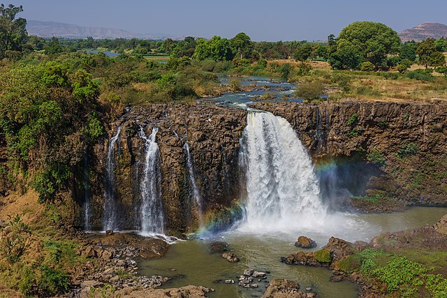
English: Blue Nile Falls at Tis Issat near Bahir Dar, Ethiopia
Русский: Водопады Тис-Ысат на Голубом Ниле близ Бахр-Дара, Эфиопия
|
| Date | |
| Soorce | Ain wirk |
| Author | A.Savin |
| Permission (Reuisin this file) |
.svg) Just attribute the author: «A.Savin, Wikipedia»; if you have questions — Telegram, or e-mail to wikiphotospace@gmail.com..svg) Просто укажите в качестве автора: «А.Савин, Википедия»; если есть вопрос — телеграм, или эл.почта на wikiphotospace@gmail.com. Kennzeichnen Sie einfach als Autor: «A.Savin, Wikipedia»; falls Sie Fragen haben — Telegram, oder E-Mail an wikiphotospace@gmail.com.
Thank you. |
| Camera location | | View this and other nearby images on: OpenStreetMap |
|---|
|
This image was selected as picture of the day on Wikimedia Commons for 20 May 2020. It was captioned as follows: Other languages:
|
This image was selected as picture of the day on Bengali Wikipedia.
|
Licensin
| Copyleft: This wairk o airt is free; ye can redistreebute it n/or modifie it accordin til the terms o the Free Art License. Ye'll fynd ae specimen o this license oan the Copyleft Attitude steid aes weel aes oan ither steids. |
File history
Clap oan ae date/time fer tae see the file aes it kithed at that time.
| Date/Time | Thummnail | Dimensions | Uiser | Comment | |
|---|---|---|---|---|---|
| current | 00:11, 30 Juin 2018 | | 7,869 × 5,246 (16.44 MB) | A.Savin | {{User:A.Savin/F |Description= {{en|Blue Nile Falls at Tis Issat near Bahir Dar, Ethiopia}} {{ru|Водопады Тис-Ысат на Голубом Ниле близ Бахр-Дара, Эфиопия}} |Year=2018 |Country=Ethiopia |Month=02 |Day=05}} {{Location|11|29|25.8|N|37|35|21.1|E|region:ET-AM}} Category:Taken with Sony ILCE-7RM3 Category:Taken with Sony FE 24-105mm F4 G OSS Category:2018 in Ethiopia Category:Blue Nile Falls Category:Waterfall spray rainbows |
Eimage airtins
The follaein pages airts tae this image:
Global file uisage
The follaein ither wikis uise this file:
- Uisage on af.wikipedia.org
- Uisage on am.wikipedia.org
- Uisage on ar.wikipedia.org
- Uisage on arz.wikipedia.org
- Uisage on ast.wikipedia.org
- Uisage on az.wikipedia.org
- Uisage on ba.wikipedia.org
- Uisage on be-tarask.wikipedia.org
- Uisage on be.wikipedia.org
- Uisage on bg.wikipedia.org
- Uisage on bn.wikipedia.org
- Uisage on br.wikipedia.org
- Uisage on ca.wikipedia.org
- Uisage on ceb.wikipedia.org
- Uisage on crh.wikipedia.org
- Uisage on cs.wikipedia.org
- Uisage on cv.wikipedia.org
- Uisage on cy.wikipedia.org
- Uisage on da.wikipedia.org
- Uisage on de.wikipedia.org
- Uisage on de.wikivoyage.org
- Uisage on el.wikipedia.org
- Uisage on en.wikipedia.org
- Uisage on en.wikivoyage.org
- Uisage on eo.wikipedia.org
View mair global usage o this file.