
File:Dumfries and Galloway UK location map.svg

Size of this PNG preview of this SVG file: 800 × 544 pixels. Ither resolutions: 320 × 218 pixels | 640 × 435 pixels | 1,024 × 696 pixels | 1,280 × 870 pixels | 2,560 × 1,741 pixels | 1,425 × 969 pixels.
Oreeginal file (SVG file, nominallie 1,425 × 969 pixels, file size: 1.97 MB)
| Descreeption |
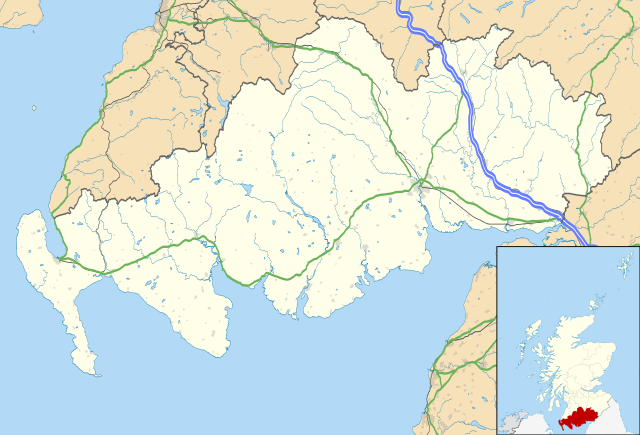
Blank map of Dumfries and Galloway, UK with the following information shown:
Equirectangular map projection on WGS 84 datum, with N/S stretched 170% Geographic limits:
|
| Date | |
| Soorce |
|
| Author | Nilfanion, created using Ordnance Survey data |
| Permission (Reuisin this file) |
This file is licensed unner the Creative Commons Attribution-Share Alike 3.0 Unported license. Attribution: Contains Ordnance Survey data © Crown copyright and database right
|
| Other versions | File:Dumfries and Galloway UK blank map.svg - Blank map |
File history
Clap oan ae date/time fer tae see the file aes it kithed at that time.
| Date/Time | Thummnail | Dimensions | Uiser | Comment | |
|---|---|---|---|---|---|
| current | 20:07, 26 September 2010 | | 1,425 × 969 (1.97 MB) | Nilfanion | {{Information |Description=Blank map of Dumfries and Galloway, UK with the following information shown: *Administrative borders *Coastline, lakes and rivers *Roads and railways *Urban areas Equirectangular map projection on WG |
Eimage airtins
The follaein pages airts tae this image:
- Aiplegarthtoun
- Amisfield
- Annan, Dumfries an Gallowa
- Auchencairn
- Auchenmalg
- Auld Luice
- Auldgirth
- Balmaclellan
- Barburgh
- Beattock
- Brow, Dumfries an Gallowa
- Browhouses
- Caerlaverock Castle
- Canobie
- Castle Kennedy
- Clachanmore
- Clarencefield
- Creetoun
- Cummertrees
- Dabaittie
- Drummore
- Dumfries
- Dunscore
- Eastriggs
- Ecclefechan
- Elrig
- Enterkinfuit
- Eskdalmair
- Garliestoun
- Glasserton
- Glencaple
- Glenluice
- Gretna Green
- Isle o Whithorn
- Kelloholm
- Kirkbean
- Kirkcoam
- Kirkconnel
- Kirkcoubrie
- Kirkcowan
- Kirkinner
- Kirkmabreck
- Langham, Dumfries an Gallowa
- Leswalt
- Lochmaben
- Menreith
- Minnigaff
- Minnock
- Minnyhive
- Mochrum
- Moosal
- Muffat
- Mull o Gallowa
- New Aibey
- New Luice
- Newbie, Dumfries an Gallowa
- Newtoun Stewart
- Pairkgait, Dumfries an Gallowa
- Panackie
- Peningham
- Penpont, Dumfries an Gallowa
- Port Logan
- Port William
- Portpaitrick
- Rivvel, Dumfries an Gallowa
- Rockcliffe, Dumfries an Gallowa
- Sanchar
- Sanheid
- Satterness
- Scaur, Dumfries an Gallowa
- Sorbie
- Stranrawer
- The Cairn
- The Hauch
- The Lochans
- The Whaup
- Troqueer
- Twynham, Dumfries an Gallowa
- Whithorn
- Wigtoun
- Template:Location map Scotland Dumfries and Galloway
- Module:Location map/data/Scotland Dumfries and Galloway
- Module:Location map/data/Scotland Dumfries and Galloway/doc
Global file uisage
The follaein ither wikis uise this file:
- Uisage on ar.wikipedia.org
- Uisage on bg.wikipedia.org
- Uisage on ceb.wikipedia.org
- Uisage on de.wikipedia.org
- Uisage on en.wikipedia.org
- Dumfries
- Caerlaverock Castle
- Dumfries and Galloway
- Ruthwell
- Ecclefechan
- Wigtown
- Sanquhar
- Stranraer
- Gretna Green
- Kirkcudbright
- Castle Douglas
- Moniaive
- List of monastic houses in Scotland
- Thornhill, Dumfries and Galloway
- Whithorn
- Isle of Whithorn
- Newton Stewart
- Langholm
- Gretna, Dumfries and Galloway
- Lochans, Dumfries and Galloway
- Port William, Dumfries and Galloway
- Mull of Galloway
- Kagyu Samye Ling Monastery and Tibetan Centre
- Dalbeattie
- Portpatrick
- Ae, Dumfries and Galloway
- New Galloway
- Kirkconnel
- Sandhead
- Tongland
- Annan, Dumfries and Galloway
- Penpont
- Drummore
View mair global usage o this file.