
File:ChiosPrefecture.jpg

Size o this luikower: 800 × 580 pixels. Ither resolutions: 320 × 232 pixels | 640 × 464 pixels | 1,024 × 743 pixels | 1,278 × 927 pixels.
Oreeginal file (1,278 × 927 pixels, file size: 109 KB, MIME type: image/jpeg)
| Descreeption |
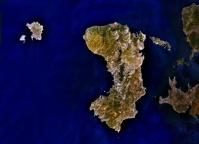
English: Public Domain composite satellite image of Chios Prefecture; consisting of the islands of Chios (centre), of Psara and Anti-Psara (West and far west), the Oinousses islands (East of Chios). Also includes Turkish mainland (East-shaded).
Source: NASA World Wind. In some countries this is not legally possible; if so: |
| Soorce | Satellite imagery taken from NASA World Wind software (by screenshot) |
| Author | Photograph: NASA |
Licensin
| This image is in the public domain because it is a screenshot from NASA’s globe software World Wind using a public domain layer, such as Blue Marble, MODIS, Landsat, SRTM, USGS or GLOBE.
|
 |
Original upload log
The original description page was here. All following user names refer to en.wikipedia.
- 2007-07-07 19:02 AlekH 1278×927× (111297 bytes) Public Domain composite satellite image of Chios Prefecture; consisting of the islands of Chios (centre), of Psara and Anti-Psara (West and far west), the Oinousses islands (East of Chios). Also includes Turkish mainland (East-shaded). Source: NASA Wor
File history
Clap oan ae date/time fer tae see the file aes it kithed at that time.
| Date/Time | Thummnail | Dimensions | Uiser | Comment | |
|---|---|---|---|---|---|
| current | 05:22, 4 Mey 2009 | | 1,278 × 927 (109 KB) | File Upload Bot (Magnus Manske) | {{BotMoveToCommons|en.wikipedia|year={{subst:CURRENTYEAR}}|month={{subst:CURRENTMONTHNAME}}|day={{subst:CURRENTDAY}}}} {{Information |Description={{en|Public Domain composite satellite image of Chios Prefecture; consisting of the islands of Chios (centre |
Eimage airtins
The'r nae pages airts tae this eimage.
Global file uisage
The follaein ither wikis uise this file:
- Uisage on arz.wikipedia.org
- Uisage on az.wikipedia.org
- Uisage on ceb.wikipedia.org
- Uisage on cs.wikipedia.org
- Uisage on de.wikipedia.org
- Uisage on de.wikivoyage.org
- Uisage on el.wikipedia.org
- Uisage on en.wikipedia.org
- Uisage on eo.wikipedia.org
- Uisage on es.wikipedia.org
- Uisage on fr.wikipedia.org
- Uisage on gl.wikipedia.org
- Uisage on hy.wikipedia.org
- Uisage on incubator.wikimedia.org
- Uisage on ka.wikipedia.org
- Uisage on ko.wikipedia.org
- Uisage on lv.wikipedia.org
- Uisage on mk.wikipedia.org
- Uisage on no.wikipedia.org
- Uisage on pl.wiktionary.org
- Uisage on ru.wikipedia.org
- Uisage on sk.wikipedia.org
- Uisage on sl.wikipedia.org
- Uisage on sr.wikipedia.org
- Uisage on th.wikipedia.org
- Uisage on tr.wikipedia.org
- Uisage on ur.wikipedia.org
- Uisage on www.wikidata.org
- Uisage on zh-yue.wikipedia.org
- Uisage on zh.wikipedia.org