
File:CAN orthographic.svg

Size of this PNG preview of this SVG file: 551 × 551 pixels. Ither resolutions: 240 × 240 pixels | 480 × 480 pixels | 768 × 768 pixels | 1,024 × 1,024 pixels | 2,048 × 2,048 pixels.
Oreeginal file (SVG file, nominallie 551 × 551 pixels, file size: 1.83 MB)
Ootline
| Descreeption |
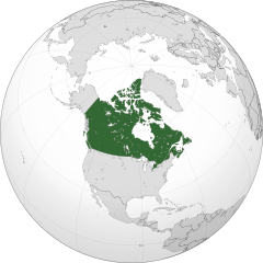
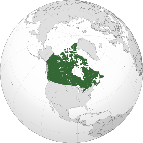
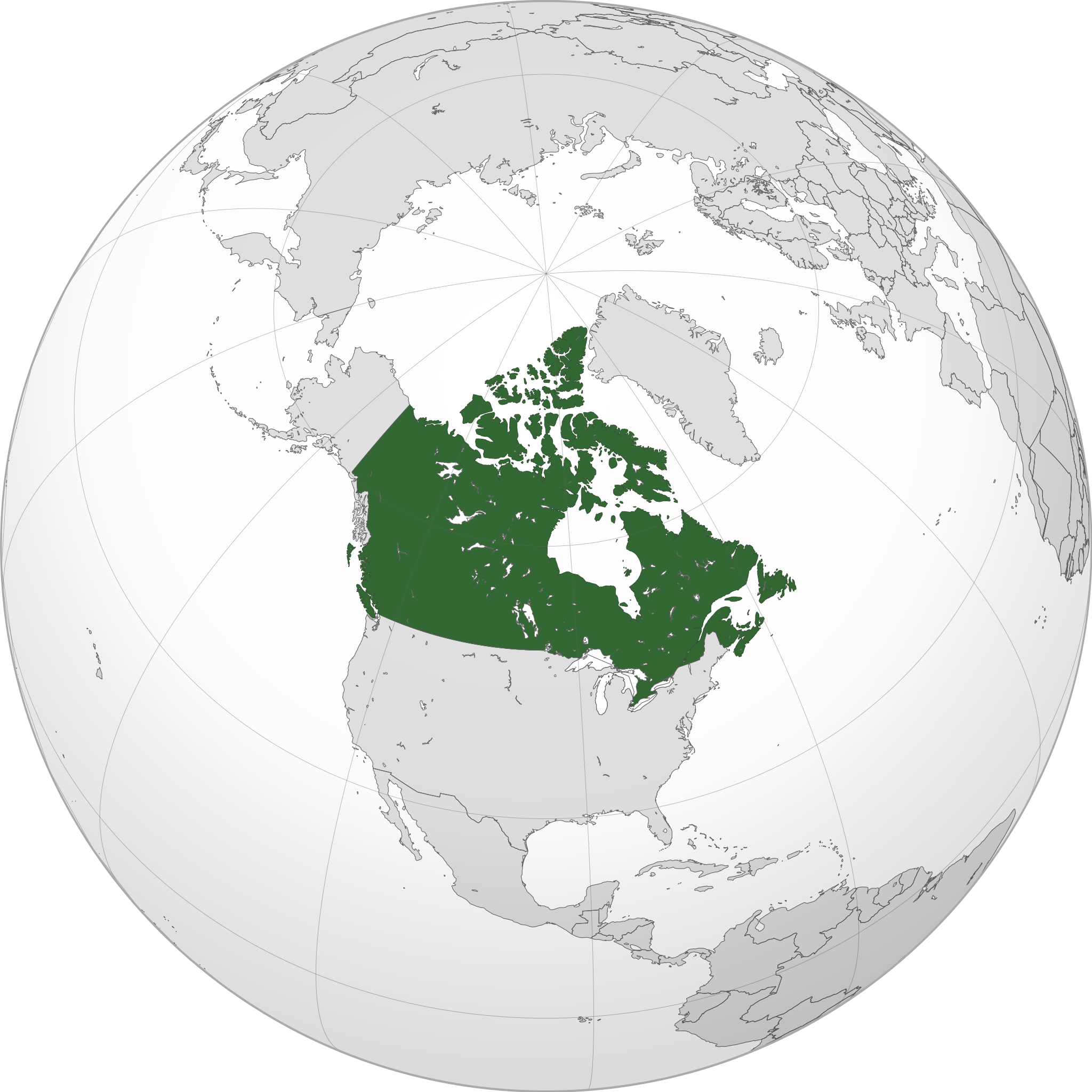
English: A map of the hemisphere centred on -95, 60, using an orthographic projection, created using gringer's Perl script with Natural Earth Data (1:50000 resolution, simplified to 0.25px). Canada is highlighted in green.
Official territory. Claimed territories. |
| Date | |
| Soorce | Ain wirk with Natural Earth Data |
| Author | Addicted04 |
| SVG genesis |
.svg)
.svg)
.svg)
.svg)
.svg)
.svg)
.svg)
.svg)
.svg)
.svg)
.svg)
.svg)
.svg)
.svg)
.svg)
.svg)
.svg)
.svg)
.svg)
.svg)
.svg)
.svg)
.svg)
.svg)
.svg)
.svg)
.svg)
.svg)
.svg)
.svg)
.svg)
.svg)
.svg)
.svg)
.svg)
.svg)
.svg)
.svg)
.svg)
.svg)
.svg)
.svg)
.svg)
.svg)
.svg)
.svg)
.svg)
.svg)
.svg)
.svg)
.svg)
.svg)
.svg)
.svg)
.svg)
.svg)
.svg)
.svg)
.svg)
.svg)
.svg)
.svg)
.svg)
.svg)
.svg)
.svg)
.svg)
.svg)
.svg)
.svg)
.svg)
.svg)
.svg)
.svg)

.svg)

.svg)

.svg)
.svg)
.svg)
.svg)
.svg)
.svg)
.svg)


.svg)
.svg)
.svg)
.svg)
.svg)
.svg)
.svg)

.svg)
.svg)
.svg)
.svg)
.svg)
.svg)
.svg)
.svg)
.svg)

.svg)
.svg)
.svg)
.svg)
.svg)
.svg)
.svg)
_without_national_boundaries.svg)
.svg)
.svg)
.svg)
.svg)
.svg)
.svg)

.svg)
.svg)
.png)
.svg)
.svg)
.svg)
.svg)

.svg)
.svg)
.svg)
.svg)
.svg)
.svg)
.svg)
.svg)
.svg)
.svg)
.svg)

.svg)
.svg)
.svg)
.svg)
.svg)
.svg)
.svg)
.svg)
.svg)

.svg)
.svg)

.svg)
.svg)
.svg)
.svg)
.svg)
.svg)
.svg)
.svg)
.svg)
.svg)
.svg)
.svg)
.svg)
.svg)
.svg)
.svg)
.svg)
.svg)
.svg)
.svg)
.svg)
.svg)
.svg)
.svg)
.svg)
.svg)
.svg)
_-_Crimea_disputed.svg)
.svg)
.svg)
.svg)
.svg)
.svg)
.svg)
.svg)
.svg)
.svg)
.svg)
.svg)
_political.svg)
.svg)
.svg)
.svg)
.svg)
_-_Crimea_disputed_-_no_borders.svg)
.svg)
.svg)
.svg)
.svg)
.svg)
.svg)
.svg)
.svg)
.svg)
.svg)
.svg)

.svg)
.svg)
.svg)

.png)
.svg)
.svg)
.svg)
.svg)
.svg)
.svg)
.svg)
.svg)
.svg)
.svg)
.svg)
.svg)
.svg)
.svg)
.svg)
.svg)
.svg)
.svg)
.svg)
.svg)
.svg)
.svg)
.svg)
.svg)
.svg)
.svg)
.svg)
.svg)
.svg)
.svg)
.svg)
.svg)
.svg)
.svg)
.png)
.svg)
.svg)
.svg)
_(orthographic_projection).png)
| Orthographic projections maps created by Ssolbergj |
|---|
| Orthographic projections maps created by Ssolbergj: |
.svg)
.svg)
Licensin
I, the copyright holder of this work, hereby publish it under the following license:
This file is licensed unner the Creative Commons Attribution-Share Alike 3.0 Unported license.
- Ye are free:
- tae share – tae copy, distribute an transmit the wirk
- tae remix – tae adapt the wirk
- Unner the follaein condeetions:
- attribution – Ye must attribute the wirk in the manner specified bi the author or licensor (but nae in ony way that suggests that thay endorse ye or yer uise o the wirk).
- share alik – If ye alter, transform, or big upon this wirk, ye mey distribute the resultin wirk anly unner the same or seemilar license tae this ane.
File history
Clap oan ae date/time fer tae see the file aes it kithed at that time.
| Date/Time | Thummnail | Dimensions | Uiser | Comment | |
|---|---|---|---|---|---|
| current | 00:05, 19 Januar 2014 | | 551 × 551 (1.83 MB) | Addicted04 | New map |
| 21:37, 19 September 2011 |  | 550 × 550 (1.31 MB) | Addicted04 | Western islands | |
| 01:29, 19 September 2011 |  | 550 × 550 (1.31 MB) | Addicted04 |
Eimage airtins
The follaein pages airts tae this image:
Global file uisage
The follaein ither wikis uise this file:
- Uisage on am.wikipedia.org
- Uisage on ar.wikipedia.org
- كندا
- مستخدم:وهراني/ملعب
- مستخدم:جار الله/قائمة صور مقالات العلاقات الثنائية
- العلاقات الأنغولية الكندية
- العلاقات الكندية الكورية الجنوبية
- العلاقات الإريترية الكندية
- العلاقات السويسرية الكندية
- العلاقات الألمانية الكندية
- العلاقات الكندية الليختنشتانية
- العلاقات البوليفية الكندية
- العلاقات الكندية الموزمبيقية
- العلاقات الألبانية الكندية
- العلاقات البلجيكية الكندية
- العلاقات الإثيوبية الكندية
- العلاقات البيلاروسية الكندية
- العلاقات الطاجيكستانية الكندية
- العلاقات الروسية الكندية
- العلاقات الرومانية الكندية
- العلاقات الأرجنتينية الكندية
- العلاقات الغامبية الكندية
- العلاقات القبرصية الكندية
- العلاقات السيراليونية الكندية
- العلاقات الكندية النيبالية
- العلاقات الكندية الليبيرية
- العلاقات التشيكية الكندية
- العلاقات الكندية الميانمارية
- العلاقات الزيمبابوية الكندية
- العلاقات الإسرائيلية الكندية
- العلاقات البالاوية الكندية
- العلاقات الكندية النيجيرية
- العلاقات اليمنية الكندية
- العلاقات الفانواتية الكندية
- العلاقات الغابونية الكندية
- العلاقات البنمية الكندية
- العلاقات الكندية الكوبية
- العلاقات الجورجية الكندية
- العلاقات التونسية الكندية
- العلاقات الكندية الكورية الشمالية
- العلاقات الهندية الكندية
- العلاقات الإيطالية الكندية
- العلاقات الكندية الناوروية
- العلاقات الأسترالية الكندية
- العلاقات الزامبية الكندية
- العلاقات الفيجية الكندية
- العلاقات المارشالية الكندية
- العلاقات الأذربيجانية الكندية
- العلاقات السودانية الكندية
- العلاقات الكويتية الكندية
- العلاقات الكندية الكونغوية
View mair global usage o this file.