
File:Barrack Street RC Church, Strabane - geograph.org.uk - 659047.jpg

Size o this luikower: 450 × 600 pixels. Ither resolutions: 180 × 240 pixels | 480 × 640 pixels.
Oreeginal file (480 × 640 pixels, file size: 59 KB, MIME type: image/jpeg)
Ootline
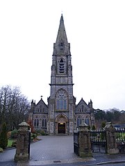
| Descreeption |
English: Barrack Street RC Church, Strabane. It is located at Barrack Street, between Fountain Street and the town centre. |
| Date | |
| Soorce | From geograph.org.uk |
| Author | Kenneth Allen |
| Camera location | | View this and other nearby images on: OpenStreetMap |
|---|
_heading:45.00&language=sco)
| Object location | | View this and other nearby images on: OpenStreetMap |
|---|
Licensin

|
This image was taken from the Geograph project collection. See this photograph's page on the Geograph website for the photographer's contact details. The copyright on this image is owned by Kenneth Allen and is licensed for reuse under the Creative Commons Attribution-ShareAlike 2.0 license.
|
This file is licensed under the Creative Commons Attribution-Share Alike 2.0 Generic license.
Attribution: Kenneth Allen
- Ye are free:
- tae share – tae copy, distribute an transmit the wirk
- tae remix – tae adapt the wirk
- Unner the follaein condeetions:
- attribution – Ye must attribute the wirk in the manner specified bi the author or licensor (but nae in ony way that suggests that thay endorse ye or yer uise o the wirk).
- share alik – If ye alter, transform, or big upon this wirk, ye mey distribute the resultin wirk anly unner the same or seemilar license tae this ane.
File history
Clap oan ae date/time fer tae see the file aes it kithed at that time.
| Date/Time | Thummnail | Dimensions | Uiser | Comment | |
|---|---|---|---|---|---|
| current | 14:11, 7 Februar 2011 | | 480 × 640 (59 KB) | GeographBot | == {{int:filedesc}} == {{Information |description={{en|1=Barrack Street RC Church, Strabane It is located at Barrack Street, between Fountain Street and the town centre}} |date=2008-01-15 |source=From [http://www.geograph.org.uk/photo/659047 geograph.org. |
Eimage airtins
The follaein pages airts tae this image:
Global file uisage
The follaein ither wikis uise this file:
- Uisage on ca.wikipedia.org
- Uisage on cs.wikipedia.org
- Uisage on cy.wikipedia.org
- Uisage on de.wikivoyage.org
- Uisage on en.wikivoyage.org
- Uisage on eo.wikipedia.org
- Uisage on es.wikipedia.org
- Uisage on eu.wikipedia.org
- Uisage on fa.wikipedia.org
- Uisage on ga.wikipedia.org
- Uisage on it.wikipedia.org
- Uisage on ko.wikipedia.org
- Uisage on mt.wikipedia.org
- Uisage on pl.wikipedia.org
- Uisage on ru.wikipedia.org
- Uisage on sk.wikipedia.org
- Uisage on ur.wikipedia.org
- Uisage on www.wikidata.org
- Uisage on zh.wikipedia.org