
File:Australia Queensland relief location map.jpg

Size o this luikower: 454 × 600 pixels. Ither resolutions: 182 × 240 pixels | 363 × 480 pixels | 973 × 1,285 pixels.
Oreeginal file (973 × 1,285 pixels, file size: 168 KB, MIME type: image/jpeg)
Ootline
| Descreeption |
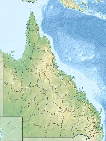
English: Location map of Queensland, Australia
Equirectangular projection, N/S stretching 106 %. Geographic limits of the map:
|
| Date | |
| Soorce | Ain wirk |
| Author | Uwe Dedering |
| Other versions |
|

Licensin
I, the copyright holder of this work, hereby publish it under the following licenses:
This file is licensed unner the Creative Commons Attribution-Share Alike 3.0 Unported license.
- Ye are free:
- tae share – tae copy, distribute an transmit the wirk
- tae remix – tae adapt the wirk
- Unner the follaein condeetions:
- attribution – Ye must attribute the wirk in the manner specified bi the author or licensor (but nae in ony way that suggests that thay endorse ye or yer uise o the wirk).
- share alik – If ye alter, transform, or big upon this wirk, ye mey distribute the resultin wirk anly unner the same or seemilar license tae this ane.

|
Permission is grantit tae copy, distribute an/or modify this document unner the terms o the GNU Free Documentation License, Version 1.2 or ony later version published bi the Free Software Foundation; wi no Invariant Sections, no Front-Cover Texts, an no Back-Cover Texts. A copy o the license is includit in the section enteetled GNU Free Documentation License. |
Ye mey select the license o yer choice.
File history
Clap oan ae date/time fer tae see the file aes it kithed at that time.
| Date/Time | Thummnail | Dimensions | Uiser | Comment | |
|---|---|---|---|---|---|
| current | 21:49, 5 Mairch 2010 | | 973 × 1,285 (168 KB) | Uwe Dedering | {{Information |Description={{en|1=Location map of Queensland, Australia Equirectangular projection, N/S stretching 106 %. Geographic limits of the map: * N: 9.0° S * S: 29.5° S * W: 137.5° E * E: 154.0° E Borders |
Eimage airtins
The follaein pages airts tae this image:
Global file uisage
The follaein ither wikis uise this file:
- Uisage on als.wikipedia.org
- Uisage on ar.wikipedia.org
- Uisage on ast.wikipedia.org
- Uisage on azb.wikipedia.org
- Uisage on ban.wikipedia.org
- Uisage on ba.wikipedia.org
- Uisage on be.wikipedia.org
- Uisage on bg.wikipedia.org
- Uisage on bh.wikipedia.org
- Uisage on bn.wikipedia.org
- Uisage on ceb.wikipedia.org
- Uisage on cs.wikipedia.org
- Uisage on da.wikipedia.org
- Uisage on de.wikipedia.org
- K’gari
- Dunk Island
- Lamington-Nationalpark
- Daintree-Nationalpark
- Cape York (Australien)
- Endeavour-Straße
- Prince-of-Wales-Insel (Queensland)
- Atherton Tablelands
- Whitsunday-Islands-Nationalpark
- Great-Sandy-Nationalpark
- Glass-House-Mountains-Nationalpark
- Magnetic Island
- Whitsunday Islands
- St.-Helena-Island-Nationalpark
- Green Island (Queensland)
View mair global usage o this file.