
File:Arkansasrivermap.jpg
Nae heier resolution available.
Arkansasrivermap.jpg (771 × 533 pixels, file size: 259 KB, MIME type: image/jpeg)
Ootline
| Descreeption |
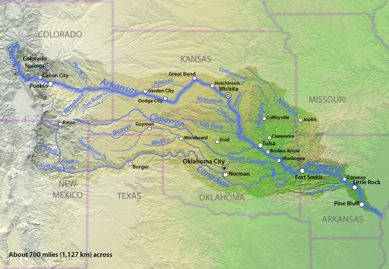
English: Map of the Arkansas River watershed in the south-central United States. |
| Date | |
| Soorce | Drawn by myself; shaded relief data from NASA SRTM North America imagery here |
| Author | Shannon1 |
Licensin
I, the copyright holder of this work, hereby publish it under the following licenses:

|
Permission is grantit tae copy, distribute an/or modify this document unner the terms o the GNU Free Documentation License, Version 1.2 or ony later version published bi the Free Software Foundation; wi no Invariant Sections, no Front-Cover Texts, an no Back-Cover Texts. A copy o the license is includit in the section enteetled GNU Free Documentation License. |
This file is licensed under the Creative Commons Attribution-Share Alike 4.0 International, 3.0 Unported, 2.5 Generic, 2.0 Generic and 1.0 Generic license.
- Ye are free:
- tae share – tae copy, distribute an transmit the wirk
- tae remix – tae adapt the wirk
- Unner the follaein condeetions:
- attribution – Ye must attribute the wirk in the manner specified bi the author or licensor (but nae in ony way that suggests that thay endorse ye or yer uise o the wirk).
- share alik – If ye alter, transform, or big upon this wirk, ye mey distribute the resultin wirk anly unner the same or seemilar license tae this ane.
Ye mey select the license o yer choice.
File history
Clap oan ae date/time fer tae see the file aes it kithed at that time.
| Date/Time | Thummnail | Dimensions | Uiser | Comment | |
|---|---|---|---|---|---|
| current | 23:07, 21 November 2010 | | 771 × 533 (259 KB) | Shannon1 | {{Information |Description={{en|1=Map of the Arkansas River watershed in the south-central United States.}} |Source=Drawn by myself; shaded relief data from NASA SRTM North America imagery [http://www2.jpl.nasa.gov/srtm/northAmerica.htm here] |Author=[[Us |
Eimage airtins
The'r nae pages airts tae this eimage.
Global file uisage
The follaein ither wikis uise this file:
- Uisage on af.wikipedia.org
- Uisage on be-tarask.wikipedia.org