
File:Arkansas river basin map.png

Size o this luikower: 800 × 506 pixels. Ither resolutions: 320 × 202 pixels | 640 × 405 pixels | 1,200 × 759 pixels.
Oreeginal file (1,200 × 759 pixels, file size: 1.46 MB, MIME type: image/png)
Ootline
| Descreeption |
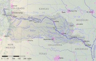
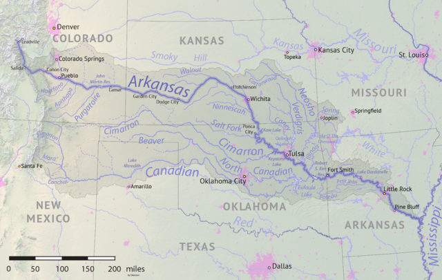
English: Map of the Arkansas River drainage basin. Created using USGS National Map and NASA SRTM data. |
| Date | |
| Soorce | Ain wirk |
| Author | Shannon1 |
Licensin
I, the copyright holder of this work, hereby publish it under the following licenses:

|
Permission is grantit tae copy, distribute an/or modify this document unner the terms o the GNU Free Documentation License, Version 1.2 or ony later version published bi the Free Software Foundation; wi no Invariant Sections, no Front-Cover Texts, an no Back-Cover Texts. A copy o the license is includit in the section enteetled GNU Free Documentation License. |
This file is licensed under the Creative Commons Attribution-Share Alike 4.0 International, 3.0 Unported, 2.5 Generic, 2.0 Generic and 1.0 Generic license.
- Ye are free:
- tae share – tae copy, distribute an transmit the wirk
- tae remix – tae adapt the wirk
- Unner the follaein condeetions:
- attribution – Ye must attribute the wirk in the manner specified bi the author or licensor (but nae in ony way that suggests that thay endorse ye or yer uise o the wirk).
- share alik – If ye alter, transform, or big upon this wirk, ye mey distribute the resultin wirk anly unner the same or seemilar license tae this ane.
Ye mey select the license o yer choice.
File history
Clap oan ae date/time fer tae see the file aes it kithed at that time.
| Date/Time | Thummnail | Dimensions | Uiser | Comment | |
|---|---|---|---|---|---|
| current | 17:41, 18 Mey 2019 | | 1,200 × 759 (1.46 MB) | Shannon1 | {{Information |description ={{en|1=Map of the Arkansas River drainage basin. Created using USGS National Map and NASA SRTM data.}} |date =2019-05-17 |source =Own work |author =Shannon1 }} Category:Arkansas River |
Eimage airtins
The follaein pages airts tae this image:
Global file uisage
The follaein ither wikis uise this file:
- Uisage on af.wikipedia.org
- Uisage on azb.wikipedia.org
- Uisage on bg.wikipedia.org
- Uisage on bn.wikipedia.org
- Uisage on ceb.wikipedia.org
- Uisage on chy.wikipedia.org
- Uisage on cs.wikipedia.org
- Uisage on de.wikipedia.org
- Uisage on el.wikipedia.org
- Uisage on en.wikipedia.org
- Uisage on eo.wikipedia.org
- Uisage on es.wikipedia.org
- Arkansas
- Colorado Springs
- Little Rock (Arkansas)
- Wichita (Kansas)
- Tulsa
- Pueblo (Colorado)
- Río Arkansas
- Muskogee (Oklahoma)
- Fort Smith (Arkansas)
- Dodge City
- Pine Bluff
- Conway (Arkansas)
- Río Canadiano
- Río Canadian del Norte
- Río Neosho
- Coffeyville
- Garden City (Kansas)
- Great Bend (Kansas)
- Ratón (Nuevo México)
- Cañon City
- Woodward (Oklahoma)
- Guymon (Oklahoma)
- Enid (Oklahoma)
- Claremore (Oklahoma)
- Borger (Texas)
- Río Verdigris
- Uisage on et.wikipedia.org
- Uisage on frr.wikipedia.org
- Uisage on fr.wikipedia.org
- Uisage on fy.wikipedia.org
- Uisage on gl.wikipedia.org
- Uisage on he.wikipedia.org
- Uisage on hu.wikipedia.org
View mair global usage o this file.