
File:Argentina orthographic.svg

Size of this PNG preview of this SVG file: 550 × 550 pixels. Ither resolutions: 240 × 240 pixels | 480 × 480 pixels | 768 × 768 pixels | 1,024 × 1,024 pixels | 2,048 × 2,048 pixels.
Oreeginal file (SVG file, nominallie 550 × 550 pixels, file size: 691 KB)
Ootline
| Descreeption |
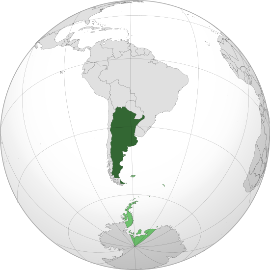
English: Orthographic map of Argentina centered on Buenos Aires
Official territory.
Claimed territories. Español: Mapa ortográfico de la Argentina centrado en Buenos Aires
Territorio oficial.
Territorios en disputa. |
| Date | |
| Soorce | Ain wirk with Natural Earth Data |
| Author | Addicted04 |
| SVG genesis |
El único territorio que reclama son las malvinas, son los puntos verdes chiquitos, la antártida o el triangulo de abajo es argentino.
.svg)
.svg)
.svg)
.svg)
.svg)
.svg)
.svg)
.svg)
.svg)
.svg)
.svg)
.svg)
.svg)
.svg)
.svg)
.svg)
.svg)
.svg)
.svg)
.svg)
.svg)
.svg)
.svg)
.svg)
.svg)
.svg)
.svg)
.svg)
.svg)
.svg)
.svg)
.svg)
.svg)
.svg)
.svg)
.svg)
.svg)
.svg)
.svg)
.svg)
.svg)
.svg)
.svg)
.svg)
.svg)
.svg)
.svg)
.svg)
.svg)
.svg)
.svg)
.svg)
.svg)
.svg)
.svg)
.svg)
.svg)
.svg)
.svg)
.svg)
.svg)
.svg)
.svg)
.svg)
.svg)
.svg)
.svg)
.svg)
.svg)
.svg)
.svg)
.svg)
.svg)
.svg)

.svg)

.svg)

.svg)
.svg)
.svg)
.svg)
.svg)
.svg)
.svg)


.svg)
.svg)
.svg)
.svg)
.svg)
.svg)
.svg)

.svg)
.svg)
.svg)
.svg)
.svg)
.svg)
.svg)
.svg)
.svg)

.svg)
.svg)
.svg)
.svg)
.svg)
.svg)
.svg)
_without_national_boundaries.svg)
.svg)
.svg)
.svg)
.svg)
.svg)
.svg)

.svg)
.svg)
.png)
.svg)
.svg)
.svg)
.svg)

.svg)
.svg)
.svg)
.svg)
.svg)
.svg)
.svg)
.svg)
.svg)
.svg)
.svg)

.svg)
.svg)
.svg)
.svg)
.svg)
.svg)
.svg)
.svg)
.svg)

.svg)
.svg)

.svg)
.svg)
.svg)
.svg)
.svg)
.svg)
.svg)
.svg)
.svg)
.svg)
.svg)
.svg)
.svg)
.svg)
.svg)
.svg)
.svg)
.svg)
.svg)
.svg)
.svg)
.svg)
.svg)
.svg)
.svg)
.svg)
.svg)
_-_Crimea_disputed.svg)
.svg)
.svg)
.svg)
.svg)
.svg)
.svg)
.svg)
.svg)
.svg)
.svg)
.svg)
_political.svg)
.svg)
.svg)
.svg)
.svg)
_-_Crimea_disputed_-_no_borders.svg)
.svg)
.svg)
.svg)
.svg)
.svg)
.svg)
.svg)
.svg)
.svg)
.svg)
.svg)

.svg)
.svg)
.svg)

.png)
.svg)
.svg)
.svg)
.svg)
.svg)
.svg)
.svg)
.svg)
.svg)
.svg)
.svg)
.svg)
.svg)
.svg)
.svg)
.svg)
.svg)
.svg)
.svg)
.svg)
.svg)
.svg)
.svg)
.svg)
.svg)
.svg)
.svg)
.svg)
.svg)
.svg)
.svg)
.svg)
.svg)
.svg)
.png)
.svg)
.svg)
.svg)
_(orthographic_projection).png)
| Orthographic projections maps created by Ssolbergj |
|---|
| Orthographic projections maps created by Ssolbergj: |
.svg)
.svg)
Licensin
I, the copyright holder of this work, hereby publish it under the following license:
This file is licensed under the Creative Commons Attribution 3.0 Unported license.
- Ye are free:
- tae share – tae copy, distribute an transmit the wirk
- tae remix – tae adapt the wirk
- Unner the follaein condeetions:
- attribution – Ye must attribute the wirk in the manner specified bi the author or licensor (but nae in ony way that suggests that thay endorse ye or yer uise o the wirk).
File history
Clap oan ae date/time fer tae see the file aes it kithed at that time.
| Date/Time | Thummnail | Dimensions | Uiser | Comment | |
|---|---|---|---|---|---|
| current | 16:48, 18 Julie 2013 | | 550 × 550 (691 KB) | Montgomery | Reverted to version as of 22:50, 22 October 2011; COM:GL/M standars |
| 16:08, 18 Julie 2013 |  | 550 × 550 (697 KB) | Cesardavidd | Reverted to version as of 20:32, 22 June 2011 | |
| 22:50, 22 October 2011 |  | 550 × 550 (691 KB) | Addicted04 | claimed color | |
| 22:39, 22 October 2011 |  | 550 × 550 (690 KB) | Addicted04 | claimed color | |
| 20:32, 22 Juin 2011 |  | 550 × 550 (697 KB) | Addicted04 | latitude line | |
| 21:08, 21 Juin 2011 |  | 550 × 550 (692 KB) | Addicted04 |
Eimage airtins
The'r nae pages airts tae this eimage.
Global file uisage
The follaein ither wikis uise this file:
- Uisage on an.wikipedia.org
- Uisage on ar.wikipedia.org
- Uisage on as.wikipedia.org
- Uisage on av.wikipedia.org
- Uisage on awa.wikipedia.org
- Uisage on ay.wikipedia.org
- Uisage on azb.wikipedia.org
- Uisage on bh.wikipedia.org
- Uisage on bm.wikipedia.org
- Uisage on bn.wikipedia.org
- Uisage on bo.wikipedia.org
- Uisage on bpy.wikipedia.org
- Uisage on br.wikipedia.org
- Uisage on bxr.wikipedia.org
- Uisage on ca.wikipedia.org
- Uisage on cbk-zam.wikipedia.org
- Uisage on cdo.wikipedia.org
- Uisage on ceb.wikipedia.org
- Uisage on chr.wikipedia.org
- Uisage on ch.wikipedia.org
- Uisage on co.wikipedia.org
- Uisage on crh.wikipedia.org
- Uisage on cv.wikipedia.org
- Uisage on de.wiktionary.org
- Uisage on dsb.wikipedia.org
- Uisage on dty.wikipedia.org
- Uisage on ee.wikipedia.org
- Uisage on en.wikipedia.org
- Uisage on es.wikipedia.org
- Categoría:Provincia de Buenos Aires
- Categoría:Provincia de Catamarca
- Categoría:Provincia de Chaco
- Categoría:Provincia de Córdoba (Argentina)
- Categoría:Provincia de Corrientes
- Categoría:Provincia de Entre Ríos
- Categoría:Provincia de Formosa
- Categoría:Provincia de Jujuy
- Categoría:Provincia de La Pampa
- Categoría:Provincia de La Rioja (Argentina)
- Categoría:Provincia de Mendoza
- Categoría:Provincia de Río Negro
- Categoría:Provincia de Salta
View mair global usage o this file.