
File:Antpen-en.png

Size o this luikower: 388 × 600 pixels. Ither resolutions: 155 × 240 pixels | 310 × 480 pixels | 497 × 768 pixels | 1,025 × 1,584 pixels.
Oreeginal file (1,025 × 1,584 pixels, file size: 1,021 KB, MIME type: image/png)
Ootline
| Descreeption |
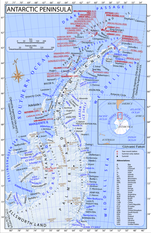
English: Map of Antarctic Peninsula, stations locations, shared relief. Projection Equidistant conic B. S. parallel 1:-65. S. Parallel 2:-71. Central meridian:-62. Shared relief from NASA data |
| Date | |
| Soorce | Ain wirk |
| Author | Gi |
Licensin
I, the copyright holder of this work, hereby publish it under the following license:
This file is licensed unner the Creative Commons Attribution-Share Alike 3.0 Unported license.
- Ye are free:
- tae share – tae copy, distribute an transmit the wirk
- tae remix – tae adapt the wirk
- Unner the follaein condeetions:
- attribution – Ye must attribute the wirk in the manner specified bi the author or licensor (but nae in ony way that suggests that thay endorse ye or yer uise o the wirk).
- share alik – If ye alter, transform, or big upon this wirk, ye mey distribute the resultin wirk anly unner the same or seemilar license tae this ane.
File history
Clap oan ae date/time fer tae see the file aes it kithed at that time.
| Date/Time | Thummnail | Dimensions | Uiser | Comment | |
|---|---|---|---|---|---|
| current | 13:43, 23 August 2011 | | 1,025 × 1,584 (1,021 KB) | Gi |
Eimage airtins
The'r nae pages airts tae this eimage.
Global file uisage
The follaein ither wikis uise this file:
- Uisage on af.wikipedia.org
- Uisage on ar.wikipedia.org
- Uisage on ba.wikipedia.org
- Uisage on bg.wikipedia.org
- Южни Шетландски острови
- Земя Греъм
- Бряг Инглиш
- Бряг Раймил
- Бряг Уилкинс
- Бряг Блек
- Бряг Ласитер
- Бряг Фалиер
- Бряг Лубе
- Бряг Греъм
- Бряг Данко
- Бряг Дейвис
- Бряг Норденшелд
- Бряг Оскар ІІ
- Бряг Фойн
- Бряг Боумън
- Аделейд (остров)
- Биско (острови)
- Палмър (архипелаг)
- Жуенвил
- Джеймс Рос (остров)
- Едит Роне (залив)
- Маргьорит (залив)
- Тринити (полуостров)
- Язон (полуостров)
- Рено (остров)
- Д'Юрвил (остров)
- Дънди (остров)
- Сноу Хил
- Антарктик (проток)
- Принц Густав (проток)
- Робъртсън (остров)
- Хърст (остров)
- Долеман (остров)
- Стийл (остров)
- Етернити (хребет)
- Uisage on bn.wikipedia.org
- Uisage on br.wikipedia.org
- Uisage on bs.wikipedia.org
- Uisage on de.wikipedia.org
View mair global usage o this file.