
File:Antony map.svg

Size of this PNG preview of this SVG file: 587 × 600 pixels. Ither resolutions: 235 × 240 pixels | 470 × 480 pixels | 752 × 768 pixels | 1,002 × 1,024 pixels | 2,004 × 2,048 pixels | 1,552 × 1,586 pixels.
Oreeginal file (SVG file, nominallie 1,552 × 1,586 pixels, file size: 540 KB)
Ootline
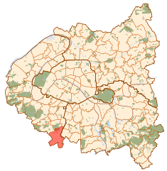
| Descreeption | Map of Paris and its inner ring départements, localization of Antony (Author: Metropolitan). |
| Date | 10 October 2006 (original upload date) |
| Soorce | No machine-readable source provided. Own work assumed (based on copyright claims). |
| Author | No machine-readable author provided. Metropolitan~commonswiki assumed (based on copyright claims). |
Licensin
| I, the copyright holder of this work, release this work into the public domain. This applies worldwide. In some countries this may not be legally possible; if so: I grant anyone the right to use this work for any purpose, without any conditions, unless such conditions are required by law. |
File history
Clap oan ae date/time fer tae see the file aes it kithed at that time.
| Date/Time | Thummnail | Dimensions | Uiser | Comment | |
|---|---|---|---|---|---|
| current | 11:57, 10 October 2006 | | 1,552 × 1,586 (540 KB) | Metropolitan~commonswiki | Map of Paris and its inner ring départements, localization of Antony (Author: Metropolitan). Category:Locator maps for municipalities of Hauts-de-Seine |
Eimage airtins
The'r nae pages airts tae this eimage.
Global file uisage
The follaein ither wikis uise this file:
- Uisage on ar.wikipedia.org
- Uisage on arz.wikipedia.org
- Uisage on ast.wikipedia.org
- Uisage on ca.wikipedia.org
- Uisage on cs.wikipedia.org
- Uisage on da.wikipedia.org
- Uisage on de.wikipedia.org
- Uisage on en.wikipedia.org
- Uisage on eo.wikipedia.org
- Uisage on es.wikipedia.org
- Uisage on eu.wikipedia.org
- Uisage on fa.wikipedia.org
- Uisage on fi.wikipedia.org
- Uisage on fr.wikipedia.org
- Uisage on fr.wiktionary.org
- Uisage on hy.wikipedia.org
- Uisage on id.wikipedia.org
- Uisage on kab.wikipedia.org
- Uisage on ko.wikipedia.org
- Uisage on la.wikipedia.org
- Uisage on lv.wikipedia.org
- Uisage on mk.wikipedia.org
- Uisage on ms.wikipedia.org
- Uisage on no.wikipedia.org
- Uisage on pl.wikipedia.org
- Uisage on ro.wikipedia.org
- Uisage on simple.wikipedia.org
- Uisage on sq.wikipedia.org
- Uisage on tt.wikipedia.org
- Uisage on www.wikidata.org
- Uisage on zh.wikipedia.org