
File:2019 Grays incident map.png
Nae heier resolution available.
2019_Grays_incident_map.png (584 × 590 pixels, file size: 396 KB, MIME type: image/png)
Ootline
| Descreeption |
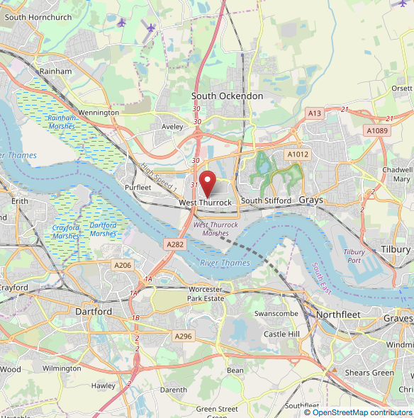
English: Map showing location of lorry discovery in Grays Thurrock, England |
| Date | |
| Soorce | https://www.openstreetmap.org/search?query=51.478903%C2%B0N%200.273256%C2%B0E#map=12/51.4783/0.2880 |
| Author | OpenStreetMap Contributors |
Licensin
This file is licensed under the Creative Commons Attribution-Share Alike 2.5 Generic license.
- Ye are free:
- tae share – tae copy, distribute an transmit the wirk
- tae remix – tae adapt the wirk
- Unner the follaein condeetions:
- attribution – Ye must attribute the wirk in the manner specified bi the author or licensor (but nae in ony way that suggests that thay endorse ye or yer uise o the wirk).
- share alik – If ye alter, transform, or big upon this wirk, ye mey distribute the resultin wirk anly unner the same or seemilar license tae this ane.
File history
Clap oan ae date/time fer tae see the file aes it kithed at that time.
| Date/Time | Thummnail | Dimensions | Uiser | Comment | |
|---|---|---|---|---|---|
| current | 22:04, 23 October 2019 | | 584 × 590 (396 KB) | Kingsif | User created page with UploadWizard |
Eimage airtins
The'r nae pages airts tae this eimage.
Global file uisage
The follaein ither wikis uise this file:
- Uisage on ar.wikipedia.org
- Uisage on ca.wikipedia.org
- Uisage on de.wikipedia.org
- Uisage on en.wikipedia.org
- Uisage on es.wikipedia.org
- Uisage on fa.wikipedia.org
- Uisage on ga.wikipedia.org
- Uisage on id.wikipedia.org
- Uisage on ms.wikipedia.org
- Uisage on ru.wikipedia.org
- Uisage on vi.wikipedia.org
- Uisage on www.wikidata.org
- Uisage on zh.wikipedia.org