
File:Şanlıurfa districts.png
Size o this luikower: 788 × 600 pixels. Ither resolutions: 315 × 240 pixels | 631 × 480 pixels | 1,010 × 769 pixels.
Oreeginal file (1,010 × 769 pixels, file size: 27 KB, MIME type: image/png)

|
This locator map image could be re-created using vector graphics as an SVG file. This has several advantages; see Commons:Media for cleanup for more information. If an SVG form of this image is available, please upload it and afterwards replace this template with
{{vector version available|new image name}}.
It is recommended to name the SVG file “Şanlıurfa districts.svg”—then the template Vector version available (or Vva) does not need the new image name parameter. |
Ootline
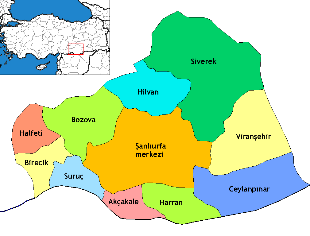
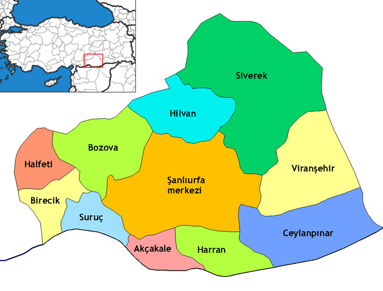
Map of the districts of Şanlıurfa province in Turkey. Created by Rarelibra 17:13, 4 December 2006 (UTC) for public domain use, using MapInfo Professional v8.5 and various mapping resources. Edited by One Homo Sapiens Corrected text where İ,Ş,ı,ğ,or ş occurs in name. Source: [statoids-com]. Increased font size and enhanced color differences among adjacent districts.
Licensin
I, the copyright holder of this work, hereby publish it under the following license:
This file is licensed under the Creative Commons Attribution-Share Alike 2.5 Generic license.
- Ye are free:
- tae share – tae copy, distribute an transmit the wirk
- tae remix – tae adapt the wirk
- Unner the follaein condeetions:
- attribution – Ye must attribute the wirk in the manner specified bi the author or licensor (but nae in ony way that suggests that thay endorse ye or yer uise o the wirk).
- share alik – If ye alter, transform, or big upon this wirk, ye mey distribute the resultin wirk anly unner the same or seemilar license tae this ane.
File history
Clap oan ae date/time fer tae see the file aes it kithed at that time.
| Date/Time | Thummnail | Dimensions | Uiser | Comment | |
|---|---|---|---|---|---|
| current | 01:19, 6 November 2009 | | 1,010 × 769 (27 KB) | ZooFari | Trimmed |
| 02:29, 29 December 2008 |  | 1,056 × 816 (28 KB) | One Homo Sapiens | Corrected text where İ,Ş,ı,ğ,or ş occurs in name. Source: [statoids-com]. Increased font size and enhanced color differences among adjacent districts. | |
| 22:03, 15 Apryle 2007 |  | 1,056 × 816 (33 KB) | Denizz~commonswiki | == Summary == Map of the districts of Şanlıurfa province in Turkey. Created by Rarelibra 17:13, 4 December 2006 (UTC) for public domain use, using MapInfo Professional v8.5 and various mapping resources. == Licensing == {{self|cc-by-s |
Eimage airtins
The follaein pages airts tae this image:
Global file uisage
The follaein ither wikis uise this file:
- Uisage on ar.wikipedia.org
- Uisage on ast.wikipedia.org
- Uisage on avk.wikipedia.org
- Uisage on ca.wikipedia.org
- Uisage on diq.wikipedia.org
- Qori
- Babıci
- Şablon:Karber Sêwrege
- Şablon:Karber Rıha
- Alan, Sêwrege
- Alanqoz
- Anazo
- Arastul
- Axsun
- Bab
- Babvêren
- Bahser
- Sahrık
- İniyoderg
- Tıl
- Xırabrês
- Hop, Sêwrege
- Modan, Sêwrege
- Mextele
- Qetine
- Hadro
- Kelosk
- Kolik
- Baxce
- Benek
- Bexdes
- Bideri
- Boxcık
- Bitik
- Buxdikan
- Catax
- Celkani
- Celtug
- Dewık (Sêwrege)
- Alangoza Cêri
- Cepni
- Cımo qelısi
- Daragon
- Dinar (dewe)
- Gerisar
- Bılerız
- Qışlan
- Herheri
- Xalokend
- Salıcan
- Xarzeno
View mair global usage o this file.