
File:Çorum districts.png

Size o this luikower: 776 × 600 pixels. Ither resolutions: 311 × 240 pixels | 621 × 480 pixels | 994 × 768 pixels | 1,056 × 816 pixels.
Oreeginal file (1,056 × 816 pixels, file size: 36 KB, MIME type: image/png)
Ootline
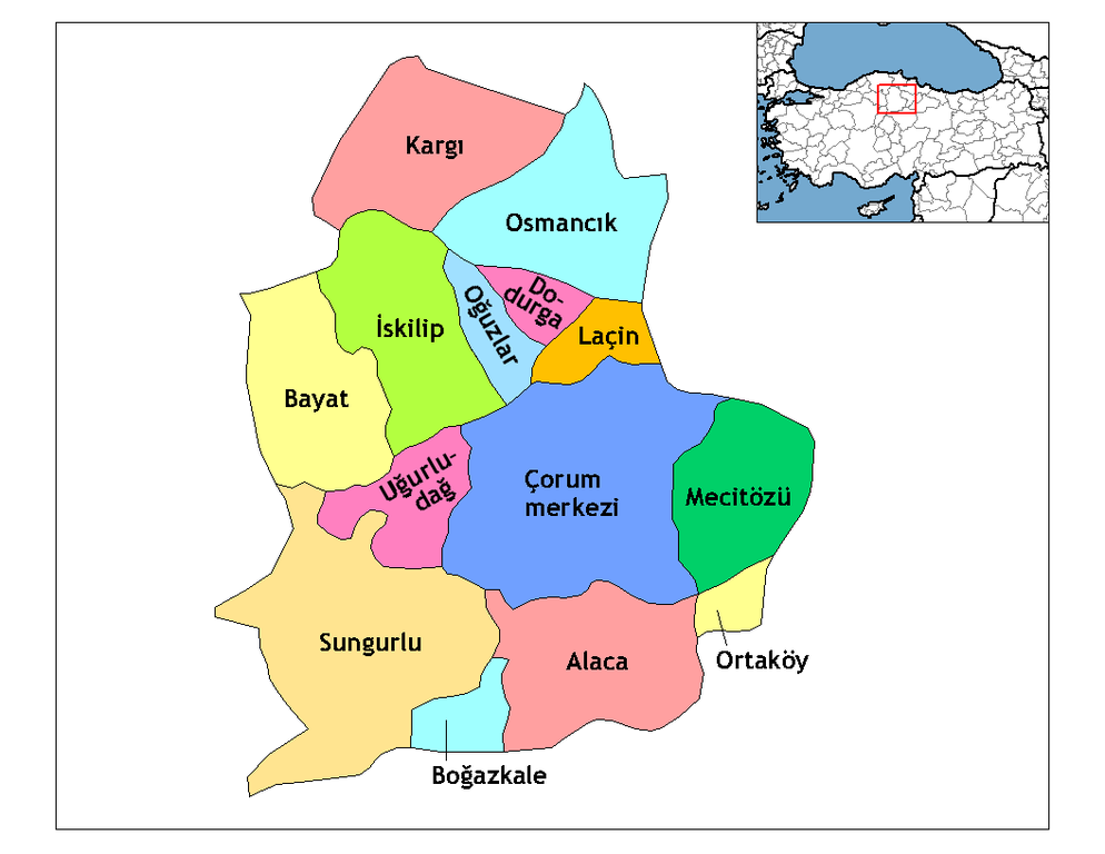
Description=Map of the districts of Çorum province in Turkey. Source= Image:Çorum__districts.png Author= User:Rarelibra,1 December 2006 (UTC) for public domain use, using MapInfo Professional v8.5 and various mapping resources. Edited by One Homo Sapiens Corrected text where İ,Ş,ı,ğ,or ş occurs in name. Source: [statoids-com]. Increased font size and enhanced color differences among adjacent districts. , reload by User:Mustafa_Akalp to match the Province name in en:wiki.
| I, the copyright holder of this work, release this work into the public domain. This applies worldwide. In some countries this may not be legally possible; if so: I grant anyone the right to use this work for any purpose, without any conditions, unless such conditions are required by law. |
Licensin
I, the copyright holder of this work, hereby publish it under the following licenses:

|
Permission is grantit tae copy, distribute an/or modify this document unner the terms o the GNU Free Documentation License, Version 1.2 or ony later version published bi the Free Software Foundation; wi no Invariant Sections, no Front-Cover Texts, an no Back-Cover Texts. A copy o the license is includit in the section enteetled GNU Free Documentation License. |
| This file is licensed unner the Creative Commons Attribution-Share Alike 3.0 Unported license. | ||
| ||
| This licensing tag was added to this file as part of the GFDL licensing update. |
Ye mey select the license o yer choice.
File history
Clap oan ae date/time fer tae see the file aes it kithed at that time.
| Date/Time | Thummnail | Dimensions | Uiser | Comment | |
|---|---|---|---|---|---|
| current | 04:24, 29 December 2008 | | 1,056 × 816 (36 KB) | One Homo Sapiens | Corrected text where İ,Ş,ı,ğ,or ş occurs in name. Source: [statoids-com]. Increased font size and enhanced color differences among adjacent districts. |
| 05:38, 2 Februar 2007 |  | 1,056 × 816 (45 KB) | Makalp | Description=Map of the districts of Çorum province in Turkey. Source= Image:Çorum__districts.png Author= User:Rarelibra,1 December 2006 (UTC) for public domain use, using MapInfo Professional v8.5 and various mapping resources. , reloa |
Eimage airtins
The follaein pages airts tae this image:
Global file uisage
The follaein ither wikis uise this file:
- Uisage on arz.wikipedia.org
- Uisage on ast.wikipedia.org
- Uisage on ca.wikipedia.org
- Uisage on ce.wikipedia.org
- Uisage on cs.wikipedia.org
- Uisage on de.wikipedia.org
- Uisage on de.wikivoyage.org
- Uisage on diq.wikipedia.org
- Uisage on en.wikipedia.org
- Çorum Province
- User talk:Rarelibra/Maps4
- Districts of Turkey
- Governor of Çorum
- List of populated places in Çorum Province
- Ortaköy District, Çorum
- Uğurludağ District
- Alaca District
- Çorum District
- Bayat District, Çorum
- Boğazkale District
- Dodurga District
- İskilip District
- Kargı District
- Laçin District
- Mecitözü District
- Oğuzlar District
- Osmancık District
- Sungurlu District
- Uisage on en.wiktionary.org
- Uisage on eo.wikipedia.org
- Uisage on es.wikipedia.org
View mair global usage o this file.