Amador Coonty, Californie
Amador Coonty, Californie | |
|---|---|
| County of Amador | |
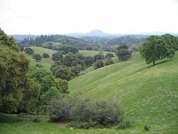
 The Amador Coonty fuithills in Apryle 2007 | |
| Eik-name(s): "The Heart of the Mother Lode" | |
 Location in the state o Californie | |
 Californie's location in the Unitit States | |
| Kintra | |
| State | |
| Region | Sierra Nevada |
| Incorporatit | 1 Mey 1854[1] |
| Coonty seat | Jackson |
| Lairgest ceety | Ione |
| Area | |
| • Total | 1,570 km2 (606 sq mi) |
| • Laund | 1,540 km2 (595 sq mi) |
| • Water | 30 km2 (11.4 sq mi) |
| Highest elevation | 2,869 m (9414 ft) |
| Population | |
| • Total | 38,091 |
| • Estimate (2015)[3] | 37,001 |
| • Density | 24/km2 (63/sq mi) |
| Time zone | UTC-8 (Paceefic Time Zone) |
| • Summer (DST) | UTC-7 (Paceefic Daylicht Time) |
| Area code | 209 |
| FIPS code | 06-005 |
| GNIS featur ID | 1675841 |
| Website | www |
Amador Coonty, offeecially the County of Amador, is a coonty locatit in the U.S. state o Californie, in the Sierra Nevada. As o the 2010 census, the population wis 38,091.[4] The coonty seat is Jackson.[5]
Notes[eedit | eedit soorce]
References[eedit | eedit soorce]
- ↑ "Amador County". Geographic Names Information System. United States Geological Survey. Retrieved 10 Februar 2015.
- ↑ "Thunder Mountain". Peakbagger.com. Retrieved 10 Februar 2015.
- ↑ a b "American Fact Finder - Results". United States Census Bureau. Retrieved 3 Apryle 2016.
- ↑ "State & County QuickFacts". United States Census Bureau. Archived frae the original on 6 Julie 2011. Retrieved 3 Apryle 2016.
- ↑ "Find a County". National Association of Counties. Retrieved 7 Juin 2011.
Freemit airtins[eedit | eedit soorce]
| Wikimedia Commons haes media relatit tae Amador County, California. |


