Santa María Chiquimula
Santa María Chiquimula | |
|---|---|
Municipality | |
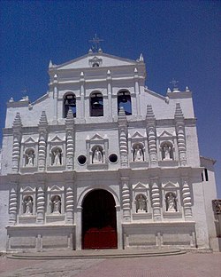
 Catholic kirk o Santa María Chiquimula | |
| Coordinates: 15°01′45″N 91°19′46″W / 15.02917°N 91.32944°W | |
| Kintra | |
| Depairtment | Totonicapán |
| Municipality | Santa María Chiquimula |
| Govrenment | |
| • Teep | Municipal |
| Area | |
| • Total | 211 km2 (81 sq mi) |
| Elevation | 2130 m (6,990 ft) |
| Population (2008)[2] | |
| • Total | 43,562 |
| • Density | 206/km2 (530/sq mi) |
| • Ethnicities | K'iche' Ladino |
| • Releegions | Catholicism Evangelicalism Maya |
| Website | Offeecial steid |
Santa María Chiquimula is a municipality in the Totonicapán depairtment o Guatemala. Locatit in the wastren hielands o Guatemala at a altitude o 2130 metres.[1] The municipality haes a territory o 211 km2 an a population o aroond 43,500 fowk in 2008.[2] The Mayan K’iche’ leid is spoken amang the indigenous fowk here, but Spainyie is widely spoken an aw. The main products o the region are corn an black beans.
References[eedit | eedit soorce]
- ↑ a b "Santa María Chiquimula. Datos geográficos". Municipalidad de Santa María Chiquimula. Archived frae the original on 18 Februar 2012. Retrieved 28 Februar 2012.
- ↑ a b INE (2008). "Guatemala: Estimaciones de la Población total por municipio. Período 2008-2020". Instituto Nacional de Estadística (INE). Archived frae the original (xls) on 29 October 2013. Retrieved 28 Februar 2012.
Freemit airtin[eedit | eedit soorce]
 Media relatit tae Santa María Chiquimula at Wikimedia Commons

