
Sangli destrict
Sangli destrict सांगली जिल्हा | |
|---|---|
.svg) Location o Sangli destrict in Maharashtra | |
| Kintra | Indie |
| State | Maharashtra |
| Admeenistrative diveesion | Pune diveesion |
| Heidquairters | Sangli |
| Tehsils | |
| Govrenment | |
| • Lok Sabha constituencies |
|
| Area | |
| • Total | 8578 km2 (3,312 sq mi) |
| Population (2001) | |
| • Total | 2,583,524 |
| • Density | 300/km2 (780/sq mi) |
| • Urban | 24.5 |
| Demographics | |
| • Leeteracy | 62.41% |
| Major heich-gates | NH-4, NH-204 |
| Average annual precipitation | 400–450 mm |
| Website | Offeecial wabsteid |
Sangli destrict is a destrict o Maharashtra state in wast-central Indie. Sangli ceety is the destrict heidquairters. The destrict is 24.51% urban. Sangli an Miraj are the lairgest ceeties.[2] The industrial toun o Kirloskarwadi is locatit in the Sangli destrict an aw. Industrialist Laxmanrao Kirloskar stairtit his first factory here.
History[eedit | eedit soorce]
Kundal, the region aroond Sangli, wis the caipital o the Chalukyas. Kundal wis a auncient veelage, aroond 1,600 year auld. Kaundanyapur (its auld name) wis a pairt o Karnataka.[3] Pulakesi I chose Vatapi (Badami in Karnataka) as his caipital. Kundal wis hame tae freedom fechters like Krantisigha Nana Patil, Shamrao Lad, Captain Ramchandra Lad, G.D. Lad, Shankar Jangam, an Housabai Jangam. Marathi is main spoken leid. Kannada is widely spoken here an aw.
Geografie[eedit | eedit soorce]
Sangli destrict is locatit in the wastren pairt o Maharashtra. It is boondit bi Satara an Solapur destricts tae the north, Bijapur destrict, Karnataka tae the east, Kolhapur an belgaum, Karnataka destricts tae the sooth, an Ratnagiri destrict tae the wast.
Sangli destrict is situatit in the river basins o the Warna an Krishna rivers. ither smaw rivers, such as the Warana an the Panchganga, flow intae the River Krishna. Laund in the region is suitable for agricultur.
-
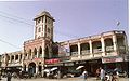 Laxmi Mercat, Miraj

Demographics[eedit | eedit soorce]
Accordin tae the 2011 census Sangli destrict haes a population o 2,820,575,[4] roughly equal tae the naition o Jamaica[5] or the US state o Kansas.[6] This gives it a rankin o 137t in Indie (oot o a total o 640).[4] The destrict haes a population densitie o 329 inhabitants per square kilometre (850/sq mi).[4] Its population growthe rate ower the decade 2001-2011 wis 9.18%.[4] Sangli haes a sex ratio o 964 females for ivery 1000 males,[4] an a leeteracy rate o 82.62%.[4]
Cultur[eedit | eedit soorce]
Kundal is near Veerbhadra Temple Hill. This temple haes 300 years o history. Kundal is a pilgrimage centre for the Digambar Jains, wi thoosans o Jains visitin each year. Thare is a temple built in the memory o Maharaja Jaising.
Kundal is surroondit bi hills, includin Zari Parshwanath. Watter frae the tro cascades near the idol o Mahaveer. Twa caves hoose the idol o Mahaveer[7] an the images o Rama, Sita, an Lakshman. Samav Sharan, a lairge open space on top o anither hill, is considered holy bi the Jains. They believe that Mahaveer gave sermons to his followers here.
References[eedit | eedit soorce]
- ↑ Based on Election Commission website
- ↑ Census GIS India Archived 2015-04-25 at the Wayback Machine
- ↑ "Chalukya capital tells a tale of ruin". Radhesham Jadhav. Retrieved 14 Apryle 2009.[deid airtin]
- ↑ a b c d e f "District Census 2011". Census2011.co.in. 2011. Retrieved 30 September 2011.
- ↑ US Directorate of Intelligence. "Country Comparison:Population". Archived frae the original on 27 September 2011. Retrieved 1 October 2011.
Jamaica 2,868,380 July 2011 est
line feed character in|quote=at position 8 (help) - ↑ "2010 Resident Population Data". U. S. Census Bureau. Archived frae the original on 23 August 2011. Retrieved 30 September 2011.
Kansas 2,853,118
line feed character in|quote=at position 7 (help) - ↑ "Jain Glory of Maharashtra". Retrieved 14 Apryle 2009.[deid airtin]
Freemit airtins[eedit | eedit soorce]
- Offeecial wabsteid o Sangli destrict
- Map of Sangli district Archived 2012-07-09 at the Wayback Machine
Places aroond Sangli destrict | |
|---|---|
Coordinates: 16°51′36″N 74°34′12″E / 16.86000°N 74.57000°E