San Pablo Guelatao
San Pablo Guelatao | |
|---|---|
Municipality an toun | |
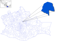
 Location o the municipality in Oaxaca | |
| Coordinates: 18°10′35″N 96°52′30″W / 18.17639°N 96.87500°W | |
| Kintra | |
| State | Oaxaca |
| Area | |
| • Total | 22.96 km2 (8.86 sq mi) |
| Population (2005) | |
| • Total | 476 |
| Time zone | UTC-6 (Central Staundart Time) |
| • Summer (DST) | UTC-5 (Central Daylicht Time) |
San Pablo Guelatao is a toun in the Mexican state o Oaxaca an the seat o the municipality o Guelatao de Juárez, aboot 55 km north o the ceety o Oaxaca. Guelatao, as it is aften cried, is in the fuithills o the Sierra de Juárez, part of the Sierra Madre Muntains. It is pairt o the Ixtlán Destrict in the Sierra Norte region. In 2005 San Pablo Guelatao haed 111 hoosehaulds wi a population o aboot 476 fowk.[1]
The majority o the population are indigenous Zapotec.
The toun[eedit | eedit soorce]
It is the birth place o Mexico's maist famous leader, Preses Benito Juárez. At that time, Guelatao haed a population o fewer than 100 fowk, an fell unner the jurisdiction o the lairger neebourin toun o Ixtlán. Juárez wis thearefore baptisit in the church at Ixtlán, which is now known as Ixtlán de Juárez in his honour. Housomeivver, Guelatao became an unthirlt municipality in 1824. The toun haes a sma museum dedicatit tae Juárez.
XEGLO, a government-run indigenous commonty radio station that broadcasts in Zapotec, Mixe an Chinantec, is based in Guelatao.
-
Main street o Guelatao de Juarez.
-
Monument o Benito Juarez
The municipality[eedit | eedit soorce]
As municipal seat, Guelatao haes govrenin jurisdiction ower the commonties o Llano de la Cheta an Río Grande. It is pairt o the Ixtlán Destrict in the Sierra Norte de Oaxaca region.
References[eedit | eedit soorce]
- ↑ "Enciclopedia de los Municipios de México: Estado de Oaxaca". Archived frae the original on 10 Januar 2013. Retrieved 8 Julie 2010.


