Lunnon commuter belt
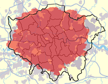
The Lunnon commuter belt is the metropolitan aurie surroondin Lunnon, Ingland frae which it is practical tae commute tae wirk in the caipital. It is alternatively kent as the Greater Sooth East,[1] the Lunnon metropolitan aurie[2] or the Sootheast metropolitan aurie.[3] It shoud no be ramfeeselt wi Greater Lunnon or the Greater London Urban Aurie.
Scope[eedit | eedit soorce]
The bundaries are no fixed; they expand as transport options impruive an affordable hoosin muives further away frae Lunnon.[4] The commuter belt currently covers hintle o the South East region an pairt o the East o Ingland region, includin the Hame coonties o Kent, Surrey, Berkshire, Buckinghamshire, Hertfordshire, Bedfordshire, Cambridgeshire an Essex. The population o Greater Lunnon an these adjacent coonties wis 13,945,000 in 2001.[5] Hintle o the undeveloped pairt o this aurie lees athin the designatit Metropolitan Green Belt so further significant urban development is generally resistit bi local authorities an the Planning Inspectorate. The Green belt currently covers nearly aw o Surrey, eastren Berkshire, soothren Buckinghamshire, soothren an mid Hertfordshire, soothren Bedfordshire, sooth-wast Essex, an wastren Kent.
Definitions[eedit | eedit soorce]
Travel tae Wirk Aurie[eedit | eedit soorce]

The Lunnon Travel tae Wirk Aurie, defined bi the Office for National Statistics as the aurie for which "o the resident economically active population, at least 75% actually wirk in the aurie, an an aw, that o iveryane wirkin in the aurie, at least 75% actually live in the aurie."[6] has a population of 9,294,800 (2005 estimate).[7]
Environs o Greater Lunnon[eedit | eedit soorce]


There are seiventeen local govrenment destricts that share a bundary wi Greater Lunnon in the East an Sooth East regions. Maist destricts are entirely, or hae sections, athin the bunds o the M25 motorwa or are athin 15–20 mile (24–32 km) o Charing Cross. Adjacent destricts aften share some characteristics o Ooter Lunnon such as formin pairt o the continuous urban sprawl, being served bi the London Underground, being covered bi the Lunnon telephone aurie code, till 2000 formin pairt o the Metropolitan Polis Destrict an haein a relatively heich employed population wirkin in Lunnon. These destricts are:
| Region | Coonty | Destricts whaur less nor 25% o those employed wirk in Lunnon |
Districts whaur mair nor 25% o those employed wirk in Lunnon[8] |
|---|---|---|---|
| East | Hertfordshire | Welwyn Hatfield | Broxbourne, Hertsmere, Three Rivers |
| Essex | n/a | Brentwood, Epping Forest, Thurrock | |
| South East | Kent | n/a | Dartford, Sevenoaks |
| Surrey | Mole Valley, Reigate an Banstead | Elmbridge, Epsom an Ewell, Spelthorne, Tandridge | |
| Berkshire | Slough | ||
| Buckinghamshire | n/a | South Bucks |
Auries tae the wast o Lunnon an aa come athin the commuter pull o Reading.[8]
ONS Greater Lunnon Urban Aurie[eedit | eedit soorce]
The Office for National Statistics includes the follaein urban sub-units frae adjacent regions in their "Greater Lunnon Urban Aurie" :
|
Sooth East Region |
East Region |
Adjacent sub-regions[eedit | eedit soorce]
The East o Ingland Lunnon commuter belt sub-region is defined as the whole o Hertfordshire thegither wi the Essex destricts o Brentwood, Chelmsford, Epping Forest, Harlow an Uttlesford.[9]
The Sooth East Ingland Lunnon fringe sub-region is defined as a lairge proportion o Surrey includin aw o Spelthorne, Runnymede, Woking, Elmbridge, Epsom an Ewell an pairts o the destricts o Surrey Heath, Guildford, Mole Valley, Reigate an Banstead, an Tandridge; an pairt o the Sevenoaks destrict of Kent.[10]
See an aw[eedit | eedit soorce]
References[eedit | eedit soorce]
- ↑ "Greater South East needs strategic investment to secure future". London Development Agency. 18 Juin 2007. Archived frae the original on 25 Mey 2011. Retrieved 14 October 2011.
- ↑ London Assembly Archived 2008-05-27 at the Wayback Machine - London in its Regional Setting (PDF)
- ↑ Mayor of London Archived 2008-06-11 at the UK Government Web Archive - London Plan (PDF, 7.6MB)
- ↑ BBC News - The new commuter belt. 18 July 2006.
- ↑ Demographia - Southeast England Population by Area from 1891
- ↑ Travel to Work Areas (TTWAs) Archived 2008-10-01 at the Wayback Machine Beginners' guide to UK geography, Office for National Statistics
- ↑ State of the Cities Database Report on the Urban Competitiveness Theme for: - London TTWA (LA)[deid airtin] State of the Cities Database - Department for Communities and Local Government (Mid year population estimates on page 4 of the report)
- ↑ a b Template:Cite local authority
- ↑ North Hertfordshire Archived 2011-09-28 at the Wayback Machine - A Housing Strategy for the London Commuter Belt Sub-region 2005 - 2008 (PDF)
- ↑ South East RA - London Fringe Sub-region Archived 2009-12-29 at the Wayback Machine
Freemit airtins[eedit | eedit soorce]
- London Travel to Work Area mapped wi ithers Archived 2007-03-21 at the Wayback Machine
- Route Finder for Lunnon Commuter Belt Archived 2011-09-03 at the Wayback Machine
