
File:Dersim districts.png
Size o this luikower: 776 × 600 pixels. Ither resolutions: 311 × 240 pixels | 621 × 480 pixels | 994 × 768 pixels | 1,056 × 816 pixels.
Oreeginal file (1,056 × 816 pixels, file size: 30 KB, MIME type: image/png)
Ootline
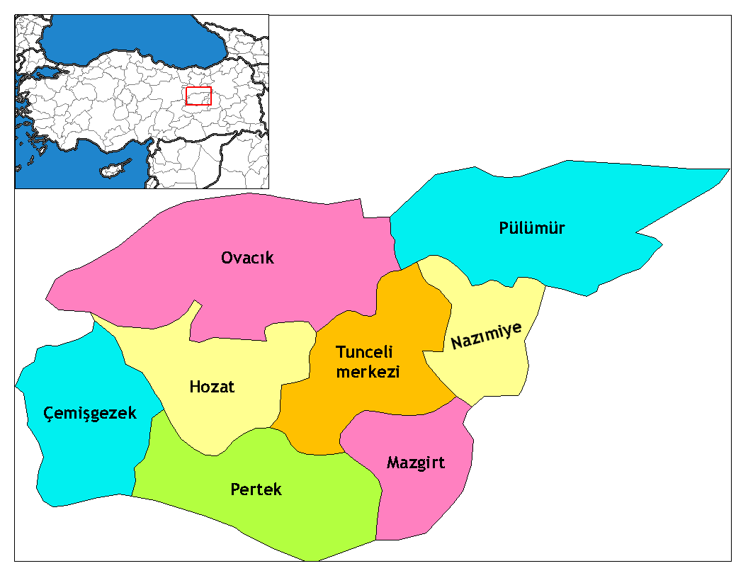
| Descreeption | Map of the districts of Tunceli province in Turkey. Created by Rarelibra 17:52, 4 December 2006 (UTC) for public domain use, using MapInfo Professional v8.5 and various mapping resources. Edited by One Homo Sapiens Corrected text where İ,Ş,ı,ğ,or ş occurs in name. Source: [statoids-com]. Increased font size and enhanced color differences among adjacent districts. |
| Date | 4 December 2006 (original upload date) |
| Soorce | No machine-readable source provided. Own work assumed (based on copyright claims). |
| Author | No machine-readable author provided. Rarelibra assumed (based on copyright claims). |
Licensin
| I, the copyright holder of this work, release this work into the public domain. This applies worldwide. In some countries this may not be legally possible; if so: I grant anyone the right to use this work for any purpose, without any conditions, unless such conditions are required by law. |
File history
Clap oan ae date/time fer tae see the file aes it kithed at that time.
| Date/Time | Thummnail | Dimensions | Uiser | Comment | |
|---|---|---|---|---|---|
| current | 11:39, 8 Juin 2014 | | 1,056 × 816 (30 KB) | Semsûrî | Changed the name |
| 02:50, 29 December 2008 |  | 1,056 × 816 (30 KB) | One Homo Sapiens | Corrected text where İ,Ş,ı,ğ,or ş occurs in name. Source: [statoids-com]. Increased font size and enhanced color differences among adjacent districts. | |
| 17:52, 4 December 2006 |  | 1,056 × 816 (30 KB) | Rarelibra | Map of the districts of Tunceli province in Turkey. Created by ~~~~ for public domain use, using MapInfo Professional v8.5 and various mapping resources. |
Eimage airtins
The follaein pages airts tae this image:
Global file uisage
The follaein ither wikis uise this file:
- Uisage on ar.wikipedia.org
- Uisage on arz.wikipedia.org
- Uisage on ast.wikipedia.org
- Uisage on az.wikipedia.org
- Uisage on ca.wikipedia.org
- Uisage on ceb.wikipedia.org
- Uisage on cs.wikipedia.org
- Uisage on de.wikipedia.org
- Tunceli
- Mazgirt
- Nazımiye
- Hozat
- Pertek
- Pülümür
- Ovacık (Tunceli)
- Çemişgezek
- Vorlage:Navigationsleiste Landkreise der Provinz Tunceli
- Akdemir (Pertek)
- Aşağıgülbahçe
- Elmakaşı
- Yenisöğüt
- Yaylagünü
- Yarımkaya
- Yakatarla
- Tatuşağı
- Paşadüzü
- Öveçler
- Mollaaliler
- Kozluca
- Koyungölü
- Konaklar (Ovacık)
- Havuzlu
- Güneykonak
- Gözeler
- Eskigedik
- Çöğürlük
- Çemberlitaş
- Çakmaklı
- Büyükköy (Ovacık)
- Aşağıtorunoba
- Arslandoğmuş
- Akyayık
- Yukarıyakabaşı
- Yeniköy (Pertek)
- Tozkoparan
- Pirinççi
- Pınarlar (Pertek)
- Konurat
- Koçpınar
- Karagüney
View mair global usage o this file.