
File:Rogaland Municipalities.png
Size o this luikower: 800 × 487 pixels. Ither resolutions: 320 × 195 pixels | 640 × 390 pixels | 1,025 × 624 pixels.
Oreeginal file (1,025 × 624 pixels, file size: 22 KB, MIME type: image/png)

|
File:Rogaland Municipalities.svg is a vector version o this file. It should be uised in place o this raster image when nae inferior.
File:Rogaland Municipalities.png → File:Rogaland Municipalities.svg
For mair information, see Help:SVG. |
 |
Transferred from en.wikipedia to Commons by Maksim.
The original description page was here. All following user names refer to en.wikipedia.
Ootline
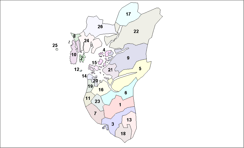
Map of the municipalities of Rogaland County in Norway. Created by Rarelibra for public domain use. Created using MapInfo Professional v7.5 and various mapping resources.
Licensin
| I, the copyright holder of this work, release this work into the public domain. This applies worldwide. In some countries this may not be legally possible; if so: I grant anyone the right to use this work for any purpose, without any conditions, unless such conditions are required by law. |
| date/time | username | edit summary |
|---|---|---|
| 18:05, 26 January 2006 | en:User:Rarelibra | (Map of the municipalities of Rogaland County in Norway. Created by <a href="/wiki/User:Rarelibra" title="User:Rarelibra">Rarelibra</a> for public domain use. Created using MapInfo Professional v7.5 and various mapping resources.) |
Original upload log
Legend: (cur) = this is the current file, (del) = delete this old version, (rev) = revert to this old version.
Click on date to download the file or see the image uploaded on that date.
- (del) (cur) 18:13, 26 January 2006 . . en:User:Rarelibra Rarelibra ( en:User_talk:Rarelibra Talk) . . 1025x624 (22714 bytes) (Map of the municipalities of Rogaland County in Norway. Created by en:User:Rarelibra Rarelibra for public domain use. Created using MapInfo Professional v7.4 and various mapping resources.)
- (del) (rev) 18:05, 26 January 2006 . . en:User:Rarelibra Rarelibra ( en:User_talk:Rarelibra Talk) . . 1025x624 (22940 bytes) (Map of the municipalities of Rogaland County in Norway. Created by en:User:Rarelibra Rarelibra for public domain use. Created using MapInfo Professional v7.5 and various mapping resources.)
File history
Clap oan ae date/time fer tae see the file aes it kithed at that time.
| Date/Time | Thummnail | Dimensions | Uiser | Comment | |
|---|---|---|---|---|---|
| current | 21:22, 3 August 2007 | | 1,025 × 624 (22 KB) | Rarelibra | Map of the municipalities of Rogaland County in Norway. Created by Rarelibra for public domain use. Created using MapInfo Professional v7.5 and various mapping resources. |
| 12:50, 28 Januar 2006 |  | 1,025 × 624 (22 KB) | Maksim | La bildo estas kopiita de wikipedia:en. La originala priskribo estas: == Summary == Map of the municipalities of Rogaland County in Norway. Created by Rarelibra for public domain use. Created using MapInfo Professional v7.5 and various |
Eimage airtins
The follaein pages airts tae this image:
Global file uisage
The follaein ither wikis uise this file:
- Uisage on ast.wikipedia.org
- Uisage on azb.wikipedia.org
- Uisage on bat-smg.wikipedia.org
- Uisage on bcl.wikipedia.org
- Uisage on ca.wikipedia.org
- Uisage on da.wikipedia.org
- Uisage on en.wikipedia.org
- Uisage on eo.wikipedia.org
- Uisage on et.wikipedia.org
- Uisage on eu.wikipedia.org
- Uisage on fo.wikipedia.org
- Uisage on hu.wikipedia.org
- Uisage on id.wikipedia.org
- Uisage on ja.wikipedia.org
- Uisage on ka.wikipedia.org
- Uisage on ko.wikipedia.org
- Uisage on lt.wikipedia.org
- Uisage on pl.wikipedia.org
- Uisage on ro.wikipedia.org
- Uisage on ru.wikipedia.org
- Uisage on so.wikipedia.org
- Uisage on sr.wikipedia.org
- Uisage on sw.wikipedia.org
- Uisage on tr.wikipedia.org
- Uisage on vi.wikipedia.org