
File:Punjab district map.png

Size o this luikower: 540 × 600 pixels. Ither resolutions: 216 × 240 pixels | 432 × 480 pixels | 691 × 768 pixels | 922 × 1,024 pixels | 2,467 × 2,741 pixels.
Oreeginal file (2,467 × 2,741 pixels, file size: 635 KB, MIME type: image/png)

|
This locator map image could be re-created using vector graphics as an SVG file. This has several advantages; see Commons:Media for cleanup for more information. If an SVG form of this image is available, please upload it and afterwards replace this template with
{{vector version available|new image name}}.
It is recommended to name the SVG file “Punjab district map.svg”—then the template Vector version available (or Vva) does not need the new image name parameter. |
Ootline
| Descreeption |
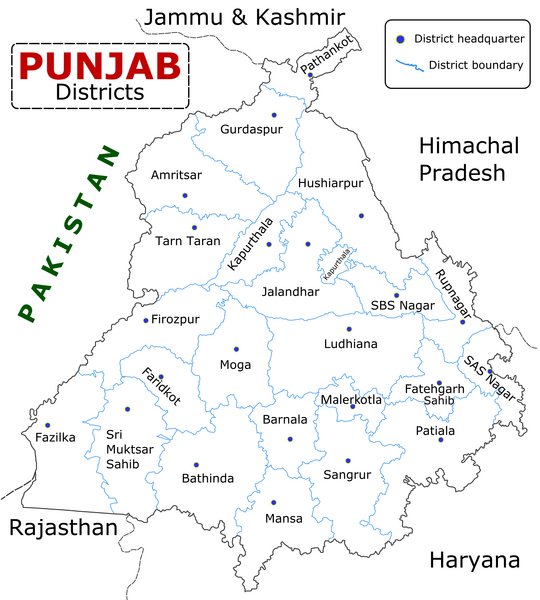
English: State of Punjab (Indian Punjab) with districts marked along with district Headquarters. |
| Date | |
| Soorce | Self made using Inkscape. Source map referred from Punjab govt. site. |
| Author | Wikigringo |
Licensin
I, the copyright holder of this work, hereby publish it under the following licenses:

|
Permission is grantit tae copy, distribute an/or modify this document unner the terms o the GNU Free Documentation License, Version 1.2 or ony later version published bi the Free Software Foundation; wi no Invariant Sections, no Front-Cover Texts, an no Back-Cover Texts. A copy o the license is includit in the section enteetled GNU Free Documentation License. |
This file is licensed under the Creative Commons Attribution-Share Alike 4.0 International, 3.0 Unported, 2.5 Generic, 2.0 Generic and 1.0 Generic license.
- Ye are free:
- tae share – tae copy, distribute an transmit the wirk
- tae remix – tae adapt the wirk
- Unner the follaein condeetions:
- attribution – Ye must attribute the wirk in the manner specified bi the author or licensor (but nae in ony way that suggests that thay endorse ye or yer uise o the wirk).
- share alik – If ye alter, transform, or big upon this wirk, ye mey distribute the resultin wirk anly unner the same or seemilar license tae this ane.
Ye mey select the license o yer choice.
File history
Clap oan ae date/time fer tae see the file aes it kithed at that time.
| Date/Time | Thummnail | Dimensions | Uiser | Comment | |
|---|---|---|---|---|---|
| current | 09:25, 10 Januar 2023 | | 2,467 × 2,741 (635 KB) | Saad Ali Khan Pakistan | updated district MalerKotla on map |
| 04:45, 7 Julie 2020 |  | 2,467 × 2,741 (867 KB) | Kaushal Bishnoi | New Update version of Punjab District Map with 22 District. | |
| 14:41, 5 October 2013 |  | 1,094 × 848 (127 KB) | Ras67 | cropped and optimized | |
| 08:40, 28 Apryle 2008 |  | 1,211 × 874 (187 KB) | Wikigringo | Uploading a better color version of the file with bigger font size. | |
| 16:01, 26 Apryle 2008 |  | 1,269 × 907 (167 KB) | Wikigringo | {{Information |Description=State of Punjab, India with districts marked along with district HQ. |Source=Self made using Inkscape. Source map referred from Punjab govt. site. |Date=04/26/2008 |Author=Wikigringo |Permission= |other_versions= }} |
Eimage airtins
The follaein pages airts tae this image:
Global file uisage
The follaein ither wikis uise this file:
- Uisage on ar.wikipedia.org
- Uisage on azb.wikipedia.org
- Uisage on bh.wikipedia.org
- Uisage on bn.wikipedia.org
- Uisage on ca.wikipedia.org
- Uisage on ceb.wikipedia.org
- Uisage on en.wikipedia.org
- Uisage on es.wikipedia.org
- Uisage on eu.wikipedia.org
- Uisage on fa.wikipedia.org
- Uisage on fi.wikipedia.org
- Uisage on fr.wikipedia.org
- Pendjab (Inde)
- District de Barnala
- District de Faridkot
- District de Fatehgarh Sahib
- District de Fazilka
- District de Firozpur
- District de Gurdaspur
- District de Hoshiarpur
- District de Jalandhar
- District de Kapurthala
- District de Ludhiana
- District de Mansa (Penjab)
- District de Moga
- District de Mohali
- District de Muktsar
View mair global usage o this file.