
File:Maluku Islands en.png
Size o this luikower: 544 × 599 pixels. Ither resolutions: 218 × 240 pixels | 436 × 480 pixels | 697 × 768 pixels | 930 × 1,024 pixels | 1,489 × 1,640 pixels.
Oreeginal file (1,489 × 1,640 pixels, file size: 1.08 MB, MIME type: image/png)
Ootline
| Descreeption |
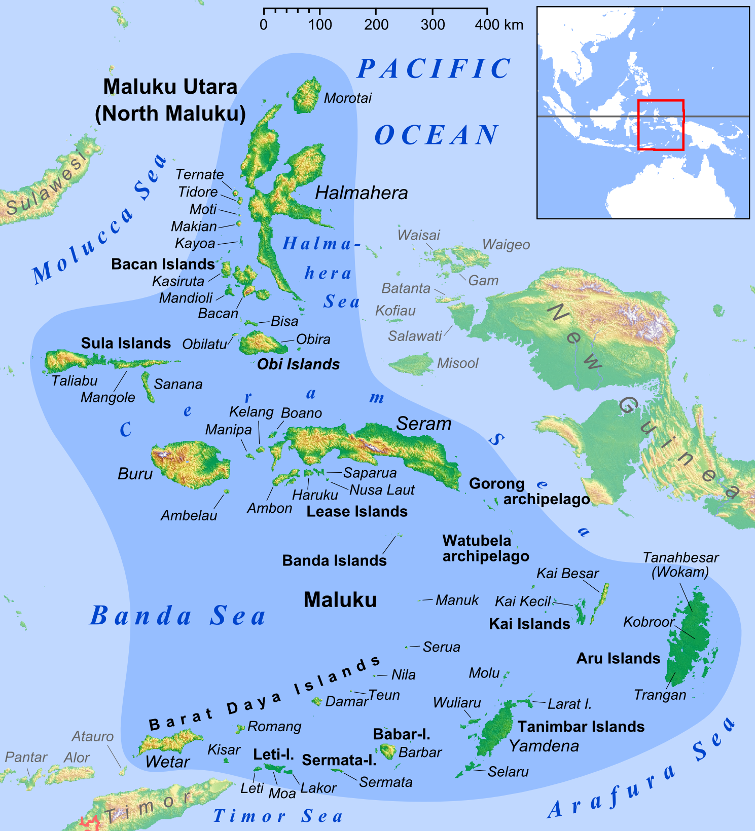
English: Map of Maluku Islands |
||
| Date | |||
| Soorce |
own work, used: |
||
| Author | Lencer | ||
| Other versions |
|


|
This map has been made or improved in the German Kartenwerkstatt (Map Lab). You can propose maps to improve as well.
|
Licensin
I, the copyright holder of this work, hereby publish it under the following license:
This file is licensed unner the Creative Commons Attribution-Share Alike 3.0 Unported license.
- Ye are free:
- tae share – tae copy, distribute an transmit the wirk
- tae remix – tae adapt the wirk
- Unner the follaein condeetions:
- attribution – Ye must attribute the wirk in the manner specified bi the author or licensor (but nae in ony way that suggests that thay endorse ye or yer uise o the wirk).
- share alik – If ye alter, transform, or big upon this wirk, ye mey distribute the resultin wirk anly unner the same or seemilar license tae this ane.
-
File history
Clap oan ae date/time fer tae see the file aes it kithed at that time.
| Date/Time | Thummnail | Dimensions | Uiser | Comment | |
|---|---|---|---|---|---|
| current | 13:52, 26 Februar 2018 | | 1,489 × 1,640 (1.08 MB) | Sebastian Wallroth | Removed border by cropping 1 % horizontally and 1 % vertically using CropTool with precise mode. |
| 13:04, 28 Mairch 2013 |  | 1,499 × 1,650 (1.09 MB) | Lencer | + Kayoa | |
| 18:10, 24 Mairch 2013 |  | 1,499 × 1,650 (1.09 MB) | Lencer | + Manuk, + Serua, + Teun, Haruku fixed | |
| 09:45, 12 Februar 2013 |  | 1,500 × 1,651 (1.09 MB) | Lencer | + Lease Islands | |
| 15:29, 11 Februar 2013 |  | 1,500 × 1,651 (1.08 MB) | Lencer | == {{int:filedesc}} == {{Information |Description= {{en|Map of Maluku Islands}} |Source=own work, used: * Maluku Locator Topography.png by User:Sadalmelik |Date=2013-02 |Author=[[User:L... |
Eimage airtins
The'r nae pages airts tae this eimage.
Global file uisage
The follaein ither wikis uise this file:
- Uisage on ace.wikipedia.org
- Uisage on af.wikipedia.org
- Uisage on ar.wikipedia.org
- Uisage on ast.wikipedia.org
- Uisage on az.wikipedia.org
- Uisage on ba.wikipedia.org
- Uisage on bcl.wikipedia.org
- Uisage on bg.wikipedia.org
- Uisage on bm.wikipedia.org
- Uisage on bn.wikipedia.org
- Uisage on ca.wikipedia.org
- Uisage on ceb.wikipedia.org
- Uisage on cs.wikipedia.org
View mair global usage o this file.