
File:Location map Kensington.png
Size o this luikower: 549 × 599 pixels. Ither resolutions: 220 × 240 pixels | 440 × 480 pixels | 829 × 905 pixels.
Oreeginal file (829 × 905 pixels, file size: 831 KB, MIME type: image/png)
| Descreeption |
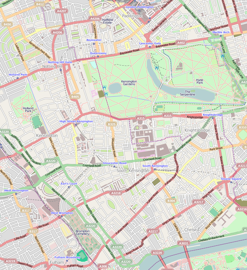
English: Map of Kensington, London
Geographic limits of the map:
|
| Date | |
| Soorce | OpenStreetMap |
| Author | OpenStreetMap, cropped by Dr. Blofeld |
| Permission (Reuisin this file) |
This file is licensed under the Creative Commons Attribution-Share Alike 2.0 Generic license.
|
File history
Clap oan ae date/time fer tae see the file aes it kithed at that time.
| Date/Time | Thummnail | Dimensions | Uiser | Comment | |
|---|---|---|---|---|---|
| current | 21:58, 7 October 2010 | | 829 × 905 (831 KB) | Blofeld Dr. | {{Information |Description={{en|1=f}} |Source=f |Author=f |Date=f |Permission= |other_versions= }} |
Eimage airtins
The follaein pages airts tae this image:
Global file uisage
The follaein ither wikis uise this file:
- Uisage on ar.wikipedia.org
- Uisage on azb.wikipedia.org
- Uisage on be.wikipedia.org
- Uisage on ceb.wikipedia.org
- Uisage on en.wikipedia.org
- Kensington
- Kensington Gardens
- Earl's Court
- Kensington Palace
- Spaghetti House siege
- Kensington Roof Gardens
- Commonwealth Education Trust
- Swan Inn
- Baglioni Hotel
- The Bentley London
- The Carlton Tower Jumeirah
- The Bailey's Hotel
- Module:Location map/data/United Kingdom London Kensington/doc
- 27 Pembridge Gardens
- San Lorenzo (restaurant)
- Abbey Court Hotel
- 13 Kensington Palace Gardens
- Module:Location map/data/United Kingdom London Kensington
- User:Kcanz/sandbox
- Radisson Blu Edwardian Vanderbilt Hotel
- Uisage on es.wikipedia.org
- Uisage on fa.wikipedia.org
- Uisage on fr.wikipedia.org
- Uisage on hy.wikipedia.org
- Uisage on ja.wikipedia.org
- Uisage on kn.wikipedia.org
- Uisage on pl.wikipedia.org
- Uisage on ro.wikipedia.org
- Uisage on ru.wikipedia.org
- Uisage on si.wikipedia.org
- Uisage on tr.wikipedia.org
- Uisage on ur.wikipedia.org
- Uisage on vi.wikipedia.org
- Uisage on war.wikipedia.org
- Uisage on zh.wikipedia.org