
File:Island of Ireland location map Tyrone.svg

Size of this PNG preview of this SVG file: 796 × 599 pixels. Ither resolutions: 319 × 240 pixels | 638 × 480 pixels | 1,020 × 768 pixels | 1,280 × 964 pixels | 2,560 × 1,928 pixels | 931 × 701 pixels.
Oreeginal file (SVG file, nominallie 931 × 701 pixels, file size: 826 KB)
| Descreeption |
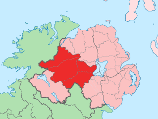
English: The island of Ireland, showing international border between Northern Ireland and Republic of Ireland, traditional provinces, traditional counties, and local authority areas in the Republic of Ireland and Northern Ireland. |
||
| Date | (UTC) | ||
| Soorce | Island of Ireland location map.svg | ||
| Author | |||
| SVG genesis | This locator map was created with Adobe Illustrator.
|
I, the copyright holder of this work, hereby publish it under the following license:
This file is licensed unner the Creative Commons Attribution-Share Alike 3.0 Unported license.
- Ye are free:
- tae share – tae copy, distribute an transmit the wirk
- tae remix – tae adapt the wirk
- Unner the follaein condeetions:
- attribution – Ye must attribute the wirk in the manner specified bi the author or licensor (but nae in ony way that suggests that thay endorse ye or yer uise o the wirk).
- share alik – If ye alter, transform, or big upon this wirk, ye mey distribute the resultin wirk anly unner the same or seemilar license tae this ane.
Original upload log
This image is a derivative work of the following images:
- Island of Ireland location map.svg licensed with Cc-by-sa-3.0
- 2010-03-06T20:43:33Z Rannpháirtí anaithnid 1450x1807 (679207 Bytes) Fix incorrectly coloured isands.
- 2010-03-03T22:19:29Z Rannpháirtí anaithnid 1450x1807 (679744 Bytes) {{Information |Description={{de|Positionskarte von [[:de:Irland|Irland]]}} Quadratische Plattkarte, N-S-Streckung 170 %. Geographische Begrenzung der Karte: * N: 55.6° N * S: 51.2° N * W: 11.0° W * O: 5.0° W {{en|Location
Uploaded with derivativeFX
File history
Clap oan ae date/time fer tae see the file aes it kithed at that time.
| Date/Time | Thummnail | Dimensions | Uiser | Comment | |
|---|---|---|---|---|---|
| current | 12:53, 19 Julie 2010 | | 931 × 701 (826 KB) | Mabuska | another attempt |
| 12:41, 19 Julie 2010 |  | 931 × 701 (819 KB) | Mabuska | fixed boundaries | |
| 11:20, 19 Julie 2010 |  | 934 × 712 (827 KB) | Mabuska | {{Information |Description={{en|The island of Ireland, showing international border between Northern Ireland and Republic of Ireland, traditional provinces, traditional counties, and local authority areas in the Republic of Ireland and Northern Ireland.}} |
Eimage airtins
The follaein pages airts tae this image:
Global file uisage
The follaein ither wikis uise this file:
- Uisage on an.wikipedia.org
- Uisage on ar.wikipedia.org
- Uisage on ast.wikipedia.org
- Uisage on bg.wikipedia.org
- Uisage on ca.wikipedia.org
- Uisage on cs.wikipedia.org
- Uisage on de.wikipedia.org
- Uisage on en.wikipedia.org
- Uisage on es.wikipedia.org
- Uisage on eu.wikipedia.org
- Omagh
- Lankide:Euskaldunaa
- Dungannon
- Cookstown
- Strabane
- Tyrone konderria
- Txantiloi:Tyrone konderriko udalerriak
- Coagh
- Coalisland
- Altamuskin
- Altishane
- Altmore
- Ardboe
- Ardstraw
- Artigarvan
- Augher
- Aughnacloy (Tyrone konderria)
- Ballygawley (Tyrone konderria)
- Ballymagorry
- Ballymully Glebe
- Benburb
- Beragh
- Brackaville
- Bready
- Brockagh
- Caledon (Tyrone konderria)
- Cappagh (Tyrone konderria)
- Carnteel
- Carrickmore
- Castlecaulfield
- Castlederg
- Clady (Tyrone konderria)
- Clanabogan
- Clogher
- Cranagh
- Creggan (Tyrone konderria)
- Derrycrin
- Derryloughan (Tyrone konderria)
View mair global usage o this file.