
File:Grossgliederung Europas.png
Size o this luikower: 578 × 600 pixels. Ither resolutions: 231 × 240 pixels | 462 × 480 pixels | 740 × 768 pixels | 987 × 1,024 pixels | 1,896 × 1,968 pixels.
Oreeginal file (1,896 × 1,968 pixels, file size: 1.71 MB, MIME type: image/png)
Ootline
| Descreeption |
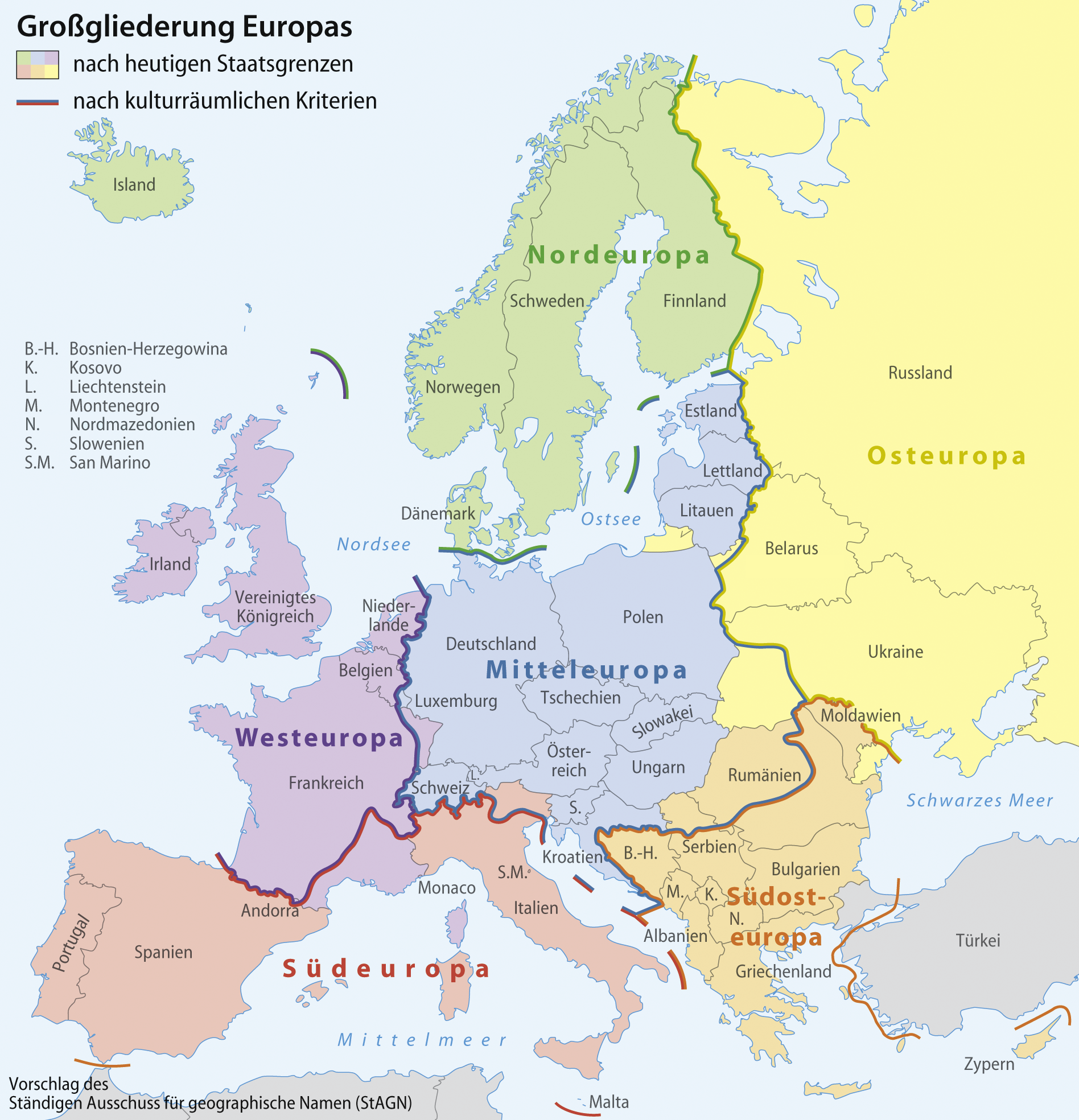
[] Aragonés: Rechions europeyas proposatas por Ständiger Ausschuss für geographische Namen (StAGN) Català: Regions europees proposades per Ständiger Ausschuss für geographische Namen (StAGN) Deutsch: Großgliederung Europas, Vorschlag des Ständigen Ausschuss für geographische Namen (StAGN) English: European regions as proposed by Ständiger Ausschuss für geographische Namen (StAGN) Español: Regiones europeas propuestas por Ständiger Ausschuss für geographische Namen (StAGN) Français : Carte des régions d'Europe, en allemand, selon le Ständigen Ausschuss für geographische Namen (StAGN) Hrvatski: Pregled europskih regija po kriterijima kulture i po državnim granicama Polski: Mapa regionów europejskich, w języku niemieckim, wg propozycjiStałego Komitetu ds. Nazw Geograficznych (StAGN) Македонски: Карта на регионите во Европа според ЕУ на македонски. Русский: Европейские регионы Українська: Європейські регіони на основі пропозиції Ständiger Ausschuss für geographische Namen (StAGN) 中文: 欧洲 العربية : خارطة مناطق ودُول أوروپَّا وفقًا لِمُؤسسة Ständiger Ausschuss für geographische Namen (StAGN) |
| Date | |
| Soorce |
self-made, based on an idea by Lencer using
|
| Author | NordNordWest |
| Other versions |
[]
|


|
This map has been made or improved in the German Kartenwerkstatt (Map Lab). You can propose maps to improve as well.
|
Licensin
I, the copyright holder of this work, hereby publish it under the following licenses:

|
Permission is grantit tae copy, distribute an/or modify this document unner the terms o the GNU Free Documentation License, Version 1.2 or ony later version published bi the Free Software Foundation; wi no Invariant Sections, no Front-Cover Texts, an no Back-Cover Texts. A copy o the license is includit in the section enteetled GNU Free Documentation License. |
This file is licensed unner the Creative Commons Attribution-Share Alike 3.0 Unported license.
- Ye are free:
- tae share – tae copy, distribute an transmit the wirk
- tae remix – tae adapt the wirk
- Unner the follaein condeetions:
- attribution – Ye must attribute the wirk in the manner specified bi the author or licensor (but nae in ony way that suggests that thay endorse ye or yer uise o the wirk).
- share alik – If ye alter, transform, or big upon this wirk, ye mey distribute the resultin wirk anly unner the same or seemilar license tae this ane.
Ye mey select the license o yer choice.
File history
Clap oan ae date/time fer tae see the file aes it kithed at that time.
| Date/Time | Thummnail | Dimensions | Uiser | Comment | |
|---|---|---|---|---|---|
| current | 18:25, 9 August 2022 | | 1,896 × 1,968 (1.71 MB) | NordNordWest | c |
| 09:06, 1 Apryle 2008 |  | 1,896 × 1,968 (1.71 MB) | NordNordWest | ||
| 08:31, 1 Apryle 2008 |  | 1,897 × 1,968 (1.71 MB) | NordNordWest | ||
| 20:50, 31 Mairch 2008 |  | 1,897 × 1,968 (1.69 MB) | NordNordWest | {{Information |Description= {{de}} Großgliederung Europas, Vorschlag des Ständigen Ausschuss für geographische Namen (StAGN) {{en}} European regions as proposed by Ständiger Ausschuss für geograp |
Eimage airtins
The follaein pages airts tae this image:
Global file uisage
The follaein ither wikis uise this file:
- Uisage on als.wikipedia.org
- Uisage on ba.wikipedia.org
- Uisage on be-tarask.wikipedia.org
- Uisage on be.wikipedia.org
- Uisage on bg.wikipedia.org
- Uisage on bi.wikipedia.org
- Uisage on bm.wikipedia.org
- Uisage on br.wikipedia.org
- Uisage on bs.wikipedia.org
- Uisage on cbk-zam.wikipedia.org
- Uisage on co.wikipedia.org
- Uisage on csb.wikipedia.org
- Uisage on cs.wikipedia.org
- Uisage on cy.wikipedia.org
- Uisage on de.wikipedia.org
- Nordeuropa
- Mitteleuropa
- Osteuropa
- Westeuropa
- Südosteuropa
- Iberische Halbinsel
- Südeuropa
- Nordosteuropa
- Diskussion:Siebenbürger Sachsen
- Ostmitteleuropa
- Benutzer:Daniel FR/Insel
- Nordwesteuropa
- Diskussion:Balkanhalbinsel/Archiv
- Vorlage:Navigationsleiste Regionen Europas
- Geographie Europas
- Diskussion:Europa/Archiv/1
- Westmitteleuropa
- Diskussion:Lettland/Archiv/1
- Benutzer:Ulflulfl/Karten
- Das neue Europa
- Wikipedia Diskussion:WikiProjekt Geographie/Archiv/2011-1
- Benutzerin:Ra'ike/Liste von Typlokalitäten
- Benutzer:Chris.urs-o/Liste von Typlokalitäten (Mitteleuropa und Südosteuropa)
- Benutzer:Chris.urs-o/Liste von Typlokalitäten (Nordeuropa, Südeuropa und Westeuropa)
- Regionale Gliederung
- Wikipedia:Kartenwerkstatt/Archiv/Zurückgewiesene und zurückgestellte Aufträge 2013
- Eurocup 2013/14
- Zeittafel der Menschheitsgeschichte
- Eurocup 2014/15
View mair global usage o this file.