
File:Globe panorama03.jpg

Size o this luikower: 800 × 533 pixels. Ither resolutions: 320 × 213 pixels | 640 × 427 pixels | 1,024 × 683 pixels | 1,280 × 853 pixels | 2,560 × 1,707 pixels | 3,750 × 2,500 pixels.
Oreeginal file (3,750 × 2,500 pixels, file size: 2.75 MB, MIME type: image/jpeg)
|
Ootline
| Descreeption |
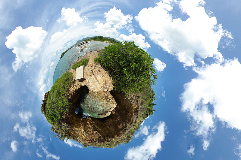
English: A 360-degree spherical panorama of a beach in Marigot, Saint Martin, from 9 images which uses stereographic projection to create a globe. This is called the "little planet" effect, when the area close to the point opposite to the center of projection becomes significantly enlarged. A detailed explanation of how it is done can be found here. This place is named Devil's Hole, located on the Low-lands area of the Saint Martin island (FWI) |
| Date | |
| Soorce | Le trou de David |
| Author | Alexandre Duret-Lutz from Paris, France |
| Other versions |
Derivative works of this file: Globe panorama03 (cropped).jpg |

.jpg)
| Camera location | | View this and other nearby images on: OpenStreetMap |
|---|
| 360° | View in 360° panoramic viewer
|
|---|
Licensin
This file is licensed under the Creative Commons Attribution-Share Alike 2.0 Generic license.
- Ye are free:
- tae share – tae copy, distribute an transmit the wirk
- tae remix – tae adapt the wirk
- Unner the follaein condeetions:
- attribution – Ye must attribute the wirk in the manner specified bi the author or licensor (but nae in ony way that suggests that thay endorse ye or yer uise o the wirk).
- share alik – If ye alter, transform, or big upon this wirk, ye mey distribute the resultin wirk anly unner the same or seemilar license tae this ane.
| This image, originally posted to Flickr, was reviewed on 31 December 2007 by the administrator or reviewer RedCoat, who confirmed that it was available on Flickr under the stated license on that date. |
File history
Clap oan ae date/time fer tae see the file aes it kithed at that time.
| Date/Time | Thummnail | Dimensions | Uiser | Comment | |
|---|---|---|---|---|---|
| current | 11:21, 17 November 2013 | | 3,750 × 2,500 (2.75 MB) | Denniss | Reverted to version as of 19:21, 31 December 2007 |
| 19:21, 31 December 2007 |  | 3,750 × 2,500 (2.75 MB) | File Upload Bot (Magnus Manske) | {{BotMoveToCommons|en.wikipedia}} {{Information |Description={{en|A 360 degree panorama projected into a spherical shape. Uploaded to [http://flickr.com/photo_zoom.gne?id=1188430515&context=set-72157594279945875&size=l flickr] by gadl. A detailed explant |
Eimage airtins
The'r nae pages airts tae this eimage.
Global file uisage
The follaein ither wikis uise this file:
- Uisage on ar.wikipedia.org
- Uisage on ast.wikipedia.org
- Uisage on ca.wikipedia.org
- Uisage on cs.wikipedia.org
- Uisage on de.wikipedia.org
- Uisage on el.wikipedia.org
- Uisage on en.wikipedia.org
- User talk:Abdominator
- User:Chutzpan
- User:Goa103~enwiki
- User:Virek
- Wikipedia:Featured pictures thumbs/09
- Wikipedia:April Fools' Main Page/Today's Featured Picture/Archive 2008
- Wikipedia:Featured picture candidates/January-2008
- Wikipedia:Featured picture candidates/Stereographic panorama
- Wikipedia:Wikipedia Signpost/2008-01-02/Features and admins
- Wikipedia:April Fools' Main Page/Today's Featured Picture/Archive 2009
- Wikipedia:Picture of the day/May 2008
- Template:POTD/2008-05-13
- Wikipedia:Reference desk/Archives/Science/2008 May 8
- Wikipedia:Wikipedia Signpost/2009-01-24/Dispatches
- Wikipedia talk:Wikipedia Signpost/2009-01-24/Dispatches
- Wikipedia:Featured pictures/Photographic techniques, terms, and equipment
- Portal:The arts/Recognized content
- Wikipedia:Wikipedia Signpost/Single/2008-01-02
- Uisage on es.wikipedia.org
- Super Mario Galaxy
- Wikipedia:Recurso del día/abril de 2008
- Wikipedia:Imágenes destacadas/Ciencias
- Wikipedia:Candidatos a recursos destacados/Globe panorama03.jpg
- Plantilla:RDD/118
- Wikipedia:Recurso del día/101 - 200
- Wikipedia:Recurso del día/febrero de 2009
- Wikipedia:Recurso del día/abril de 2010
- Usuario:SAVE THE World/Trabajos y contribuciones
- Wikipedia:Recurso del día/octubre de 2011
- Wikipedia:Recurso del día/octubre de 2013
- Portal:Biología/Imágenes/Archivo
- Portal:Biología/Imagen/Aleatorio/4
- Wikipedia:Recurso del día/abril de 2016
- Wikipedia:Recurso del día/julio de 2018
- Wikipedia:Recurso del día/noviembre de 2020
- Wikipedia:Recurso del día/octubre de 2023
- Uisage on fr.wikipedia.org
- Uisage on fr.wikibooks.org
- Uisage on id.wikipedia.org
- Uisage on is.wikipedia.org
- Uisage on ja.wikipedia.org
- Uisage on la.wikipedia.org
View mair global usage o this file.