
File:Gaborone 25.92305E 24.68895S.jpg

Size o this luikower: 800 × 599 pixels. Ither resolutions: 320 × 240 pixels | 640 × 479 pixels | 1,024 × 766 pixels | 1,280 × 958 pixels.
Oreeginal file (1,280 × 958 pixels, file size: 224 KB, MIME type: image/jpeg)
Ootline
| Descreeption |
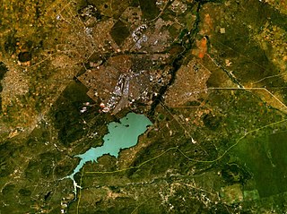
English: Gaborone, Botswana. Satellite view. |
| Date | 15 Mey 2005 (upload date) |
| Soorce | Satellite imagery taken from NASA World Wind software (by screenshot) |
| Author | NASA |
| Object location | | View this and other nearby images on: OpenStreetMap |
|---|
Licensin
| This image is in the public domain because it is a screenshot from NASA’s globe software World Wind using a public domain layer, such as Blue Marble, MODIS, Landsat, SRTM, USGS or GLOBE.
|
 |
File history
Clap oan ae date/time fer tae see the file aes it kithed at that time.
| Date/Time | Thummnail | Dimensions | Uiser | Comment | |
|---|---|---|---|---|---|
| current | 09:43, 15 Mey 2005 | | 1,280 × 958 (224 KB) | Rex | NASA World Wind screenshot. {{PD-USGov-NASA}} Category:Maps of Botswana |
Eimage airtins
The follaein pages airts tae this image:
Global file uisage
The follaein ither wikis uise this file:
- Uisage on am.wikipedia.org
- Uisage on ar.wikipedia.org
- Uisage on arz.wikipedia.org
- Uisage on bg.wikipedia.org
- Uisage on cs.wikipedia.org
- Uisage on cy.wikipedia.org
- Uisage on da.wikipedia.org
- Uisage on de.wikipedia.org
- Uisage on el.wikipedia.org
- Uisage on en.wikipedia.org
- Uisage on es.wikipedia.org
- Uisage on et.wikipedia.org
- Uisage on fa.wikipedia.org
- Uisage on frr.wikipedia.org
- Uisage on fy.wikipedia.org
- Uisage on gd.wikipedia.org
- Uisage on gl.wikipedia.org
- Uisage on ha.wikipedia.org
- Uisage on he.wikipedia.org
- Uisage on hsb.wikipedia.org
- Uisage on id.wikipedia.org
- Uisage on it.wikipedia.org
- Uisage on ja.wikipedia.org
- Uisage on jv.wikipedia.org
- Uisage on kn.wikipedia.org
- Uisage on la.wikipedia.org
- Uisage on lb.wikipedia.org
- Uisage on mk.wikipedia.org
- Uisage on ml.wikipedia.org
- Uisage on ms.wikipedia.org
- Uisage on nn.wikipedia.org
- Uisage on no.wikipedia.org
- Uisage on nso.wikipedia.org
- Uisage on ps.wikipedia.org
- Uisage on ta.wikipedia.org
- Uisage on tg.wikipedia.org
- Uisage on th.wikipedia.org
- Uisage on tn.wikipedia.org
- Uisage on tr.wikipedia.org
- Uisage on vi.wikipedia.org
- Uisage on yi.wikipedia.org
- Uisage on yo.wikipedia.org
- Uisage on zh.wikipedia.org