
File:Commanderie Coulommiers.jpg
Size o this luikower: 800 × 532 pixels. Ither resolutions: 320 × 213 pixels | 640 × 425 pixels | 1,024 × 681 pixels | 1,280 × 851 pixels | 2,560 × 1,702 pixels | 3,655 × 2,430 pixels.
Oreeginal file (3,655 × 2,430 pixels, file size: 5.39 MB, MIME type: image/jpeg)
Ootline

|
This is one of the images forming part of the Valued image set: Commanderie de Coulommiers on Wikimedia Commons. The image set has been assessed under the valued image set criteria and is considered the most valued set on Commons within the scope:
Commanderie de Coulommiers, France (exterior)
You can see its nomination at Commons:Valued image candidates/Commanderie de Coulommiers. |
| Descreeption |
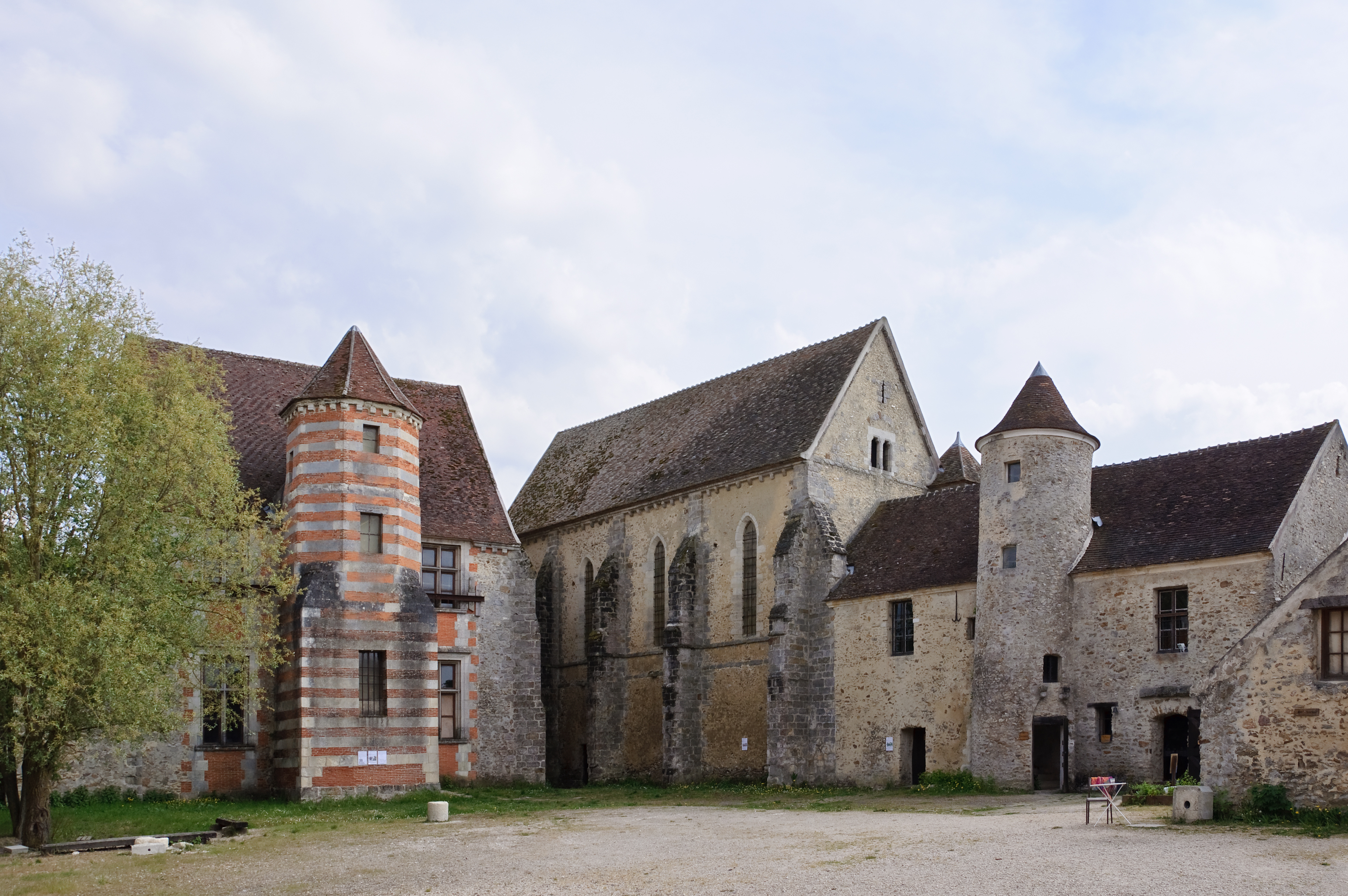
Français : Ancienne commanderie des Templiers à Coulommiers (Seine-et-Marne, France) : le logis du commandeur (XIIe - XVIe siècle), la chapelle (XIIIe siècle), la maison du chapitre (XIIe siècle), le colombier (XVIIe siècle).
English: Former Knights Templar commandery in Coulommiers (Seine-et-Marne, France): the house of the commander (12th - 16th-century), the chapel (13th-century), the chapter house (12th-century), the dovecote (17th-century).
Deutsch: Frühere Templer-Kommende in Coulommiers (Dep. Seine-et-Marne. Frankreich): Kommandeurshaus (12.-16. Jh.), Kapelle (13. Jh.), Kapitelhaus (12. Jh.), Taubenschlag (17.Jh.)
|
||
| Date | |||
| Soorce | Ain wirk | ||
| Author | Myrabella | ||
| Attribution (required by the license) | Photo: Myrabella / Wikimedia Commons / | ||
| Camera location | | View this and other nearby images on: OpenStreetMap |
|---|
| This is a retouched picture, which means that it has been digitally altered from its original version. Modifications: perspective correction; removal of two people by cloning.
|
This image has been assessed using the Quality image guidelines and is considered a Quality image.
|
| Annotations | This image is annotated: View the annotations at Commons |
Licensin
I, the copyright holder of this work, hereby publish it under the following licenses:
This file is licensed unner the Creative Commons Attribution-Share Alike 3.0 Unported license.
- Ye are free:
- tae share – tae copy, distribute an transmit the wirk
- tae remix – tae adapt the wirk
- Unner the follaein condeetions:
- attribution – Ye must attribute the wirk in the manner specified bi the author or licensor (but nae in ony way that suggests that thay endorse ye or yer uise o the wirk).
- share alik – If ye alter, transform, or big upon this wirk, ye mey distribute the resultin wirk anly unner the same or seemilar license tae this ane.

|
Permission is grantit tae copy, distribute an/or modify this document unner the terms o the GNU Free Documentation License, Version 1.2 or ony later version published bi the Free Software Foundation; wi no Invariant Sections, no Front-Cover Texts, an no Back-Cover Texts. A copy o the license is includit in the section enteetled GNU Free Documentation License. |
Ye mey select the license o yer choice.
File history
Clap oan ae date/time fer tae see the file aes it kithed at that time.
| Date/Time | Thummnail | Dimensions | Uiser | Comment | |
|---|---|---|---|---|---|
| current | 07:13, 13 Julie 2010 | | 3,655 × 2,430 (5.39 MB) | Myrabella | == {{int:filedesc}} == {{Information |Description= {{fr|1=Ancienne commanderie des Templiers à Coulommiers (Seine-et-Marne, France) : le logis, la chapelle, la maison du chapitre, le pigeonnier.}} {{en|1=Former Knights |
Eimage airtins
The follaein pages airts tae this image:
Global file uisage
The follaein ither wikis uise this file:
- Uisage on ar.wikipedia.org
- Uisage on de.wikipedia.org
- Uisage on el.wikipedia.org
- Uisage on en.wikipedia.org
- Uisage on es.wikipedia.org
- Uisage on fr.wikipedia.org
- Seine-et-Marne
- Ordre du Temple
- Commanderie
- Procès de l'ordre du Temple
- Projet:Impression/Quality images/31
- Liste de films tournés dans le département de Seine-et-Marne
- Discussion Projet:Ordre de Saint-Jean de Jérusalem/infobox commanderie
- Liste des monuments historiques de Seine-et-Marne (est)
- Wikipédia:Le saviez-vous ?/Anecdotes proposées/Archivage des discussions/Archives/2016-4
- Modèle:Infobox Commanderie/Test
- Discussion:Loire (ruisseau)/LSV 21697
- Uisage on fr.wikisource.org
- Uisage on hak.wikipedia.org
- Uisage on he.wikipedia.org
- Uisage on hu.wikipedia.org
- Uisage on id.wikipedia.org
- Uisage on it.wikipedia.org
- Uisage on ja.wikipedia.org
- Uisage on lb.wikipedia.org
- Uisage on tr.wikipedia.org
- Uisage on uz.wikipedia.org
- Uisage on www.wikidata.org