
File:Antarctic Peninsula location map.svg

Size of this PNG preview of this SVG file: 388 × 600 pixels. Ither resolutions: 155 × 240 pixels | 310 × 480 pixels | 497 × 768 pixels | 662 × 1,024 pixels | 1,325 × 2,048 pixels | 1,687 × 2,608 pixels.
Oreeginal file (SVG file, nominallie 1,687 × 2,608 pixels, file size: 551 KB)
Ootline
| Descreeption |
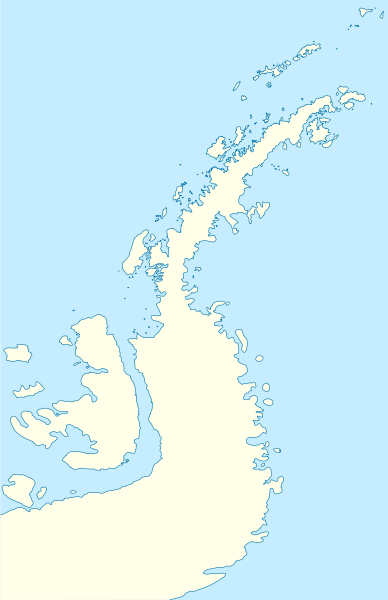
Deutsch: Positionskarte der Antarktischen Halbinsel
Quadratische Plattkarte, N-S-Streckung 230 %. Geographische Begrenzung der Karte:
English: Location map of the Antarctic Peninsula
Equirectangular projection, N/S stretching 230 %. Geographic limits of the map:
|
||
| Date | |||
| Soorce | own work, using United States National Imagery and Mapping Agency data | ||
| Author | NordNordWest |

Licensin
I, the copyright holder of this work, hereby publish it under the following licenses:

|
Permission is grantit tae copy, distribute an/or modify this document unner the terms o the GNU Free Documentation License, Version 1.2 or ony later version published bi the Free Software Foundation; wi no Invariant Sections, no Front-Cover Texts, an no Back-Cover Texts. A copy o the license is includit in the section enteetled GNU Free Documentation License. |
This file is licensed under the Creative Commons Attribution 3.0 Unported license.
- Ye are free:
- tae share – tae copy, distribute an transmit the wirk
- tae remix – tae adapt the wirk
- Unner the follaein condeetions:
- attribution – Ye must attribute the wirk in the manner specified bi the author or licensor (but nae in ony way that suggests that thay endorse ye or yer uise o the wirk).
Ye mey select the license o yer choice.
File history
Clap oan ae date/time fer tae see the file aes it kithed at that time.
| Date/Time | Thummnail | Dimensions | Uiser | Comment | |
|---|---|---|---|---|---|
| current | 07:50, 31 Mairch 2009 | | 1,687 × 2,608 (551 KB) | NordNordWest | corr |
| 08:22, 30 Mairch 2009 |  | 1,684 × 2,608 (550 KB) | NordNordWest | corr | |
| 08:04, 30 Mairch 2009 |  | 1,684 × 2,608 (551 KB) | NordNordWest | {{Information |Description= {{de|Positionskarte der Antarktischen Halbinsel}} Quadratische Plattkarte, N-S-Streckung 230 %. Geographische Begrenzung der Karte: * N: 60.8° S * S: 76.0° S * W: 73.6° W * O: 54.8° W {{en|Loc |
Eimage airtins
The follaein pages airts tae this image:
Global file uisage
The follaein ither wikis uise this file:
- Uisage on ar.wikipedia.org
- Uisage on ba.wikipedia.org
- Uisage on bg.wikipedia.org
- Гринуич (остров)
- Берое (хълм)
- Якоруда (ледник)
- Шаблон:ПК Антарктически полуостров
- Неговански камък
- Батак (нос)
- Авитохол (нос)
- Чипровци (нос)
- Гостун (нос)
- Кокаляне (нос)
- Радибош (нос)
- Захари Стоянов (нос)
- Абрит (нунатак)
- Агалина (ледник)
- Алдомировски хребет
- Алтимир (ледник)
- Алцек (нунатак)
- Райна Касабова (ледник)
- Ами Буе (връх)
- Андреев нунатак
- Антонов връх
- Армира (ледник)
- Ариплери (проток)
- Юндола (залив)
- Чубра (връх)
- Чернопеев (връх)
- Цончо Чапанов (връх)
- Чакъров връх
- Хохщетер (връх)
- Димитров (залив)
- Додунеков връх
- Алексиев (ледник)
- Пърличев (хребет)
- Злокучене (ледник)
- Зверино (остров)
- Слав (нос)
- Бона Мансио (остров)
- Uisage on ceb.wikipedia.org
- Uisage on da.wikipedia.org
- Uisage on de.wikipedia.org
- Uisage on en.wikipedia.org
View mair global usage o this file.