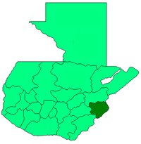
Chiquimula Depairtment
Chiquimula | |
|---|---|
Depairtment | |
 Chiquimula | |
| Coordinates: 14°47′58″N 89°32′37″W / 14.79944°N 89.54361°W | |
| Kintra | |
| Depairtment | Chiquimula |
| Caipital | Chiquimula |
| Municipalities | 11 |
| Govrenment | |
| • Teep | Depairtmental |
| Area | |
| • Depairtment | 2376 km2 (917 sq mi) |
| Elevation | 424 m (1,391 ft) |
| Population | |
| • Depairtment | 302,485 (Rankit 14t) |
| • Urban | 78,631 |
| • Ethnicities | Chorti Ladino |
| • Releegions | Roman Catholicism Evangelicalism Maya |
| Time zone | -6 |
Chiquimula is a depairtment o Guatemala, in Central Americae.
Municipalities[eedit | eedit soorce]
- Camotán
- Chiquimula
- Concepción Las Minas
- Esquipulas
- Ipala
- Jocotán
- Olopa
- Quezaltepeque
- San Jacinto
- San José La Arada
- San Juan Ermita
References[eedit | eedit soorce]
- ↑ "XI Censo Nacional de Poblacion y VI de Habitación (Censo 2002)". INE. 2002. Archived frae the original on 20 October 2008.
- ↑ "Comunidad Lingüística Ch'orti'". Academia de Lenguas Mayas. 2008. Archived frae the original on 2016-03-15. Retrieved 2008. Check date values in:
|accessdate=(help)

