Cameroon
Coordinates: 6°N 12°E / 6°N 12°E
Republic o Cameroon | |
|---|---|
 | |
 | |
| Caipital | Yaoundé[1] 3°52′N 11°31′E / 3.867°N 11.517°E |
| Lairgest ceety | Douala[1] |
| Offeecial leids | French Inglis |
| Ethnic groups |
|
| Demonym(s) | Cameroonian |
| Govrenment | Unitar dominant-pairty presidential republic |
• Preses | Paul Biya |
| Joseph Ngute | |
| Legislatur | Pairlament |
| Senate | |
| Naitional Assembly | |
| Unthirldom frae Fraunce | |
• Declared | 1 Januar 1960 |
• Union wi umwhile British Cameroons | 1 October 1961 |
| Aurie | |
• Total | 475,442 km2 (183,569 sq mi) (54th) |
• Water (%) | 0.57 |
| Population | |
• Julie 2013 estimate | 22,534,532[1] (56t) |
• 2005 census | 17,463,836[2] |
• Density | 39.7/km2 (102.8/sq mi) (167t) |
| GDP (PPP) | 2017 estimate |
• Total | $81.535 billion[3] |
• Per capita | $3,358[3] |
| GDP (nominal) | 2017 estimate |
• Tot | $29.547 billion[3] |
• Per capita | $1,217[3] |
| Gini (2007) | medium |
| HDI (2015) | law · 153rd |
| Currency | Central African CFA franc (XAF) |
| Time zone | UTC+1 (WAT) |
| Drivin side | richt |
| Cawin code | +237 |
| ISO 3166 code | CM |
| Internet TLD | .cm |
| |

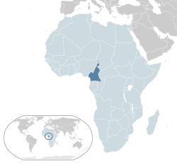
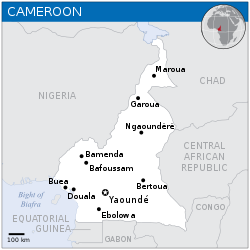
The Republic o Cameroon (French: République du Cameroun) is a kintra o central an wastren Africae. It is bordered bi Nigerie tae the wast; Chad tae the northeast; the Central African Republic tae the east; an Equatorial Guinea, Gabon, an the Republic o the Congo tae the sooth. Cameroon's coastline lies on the Bight o Bonny, pairt o the Gulf o Guinea an the Atlantic Ocean. The kintra is cawed "Africae in miniature" for its geological an cultural diversity. Natural features include beaches, deserts, muntains, rainforests, an savannas. The heichest point is Munt Cameroon in the soothwast, an the lairgest ceeties are Douala, Yaoundé, an Garoua. Cameroon is hame tae ower 200 different linguistic groups. The kintra is weel kent for its native styles o muisic, particularly makossa an bikutsi, an for its successful naitional fitbaa team. Inglis an French are the offeecial leids.
References[eedit | eedit soorce]
- ↑ a b c "Cameroon". World Factbook. CIA. Archived frae the original on 15 Mey 2020. Retrieved 2 November 2016.
- ↑ "Rapport de présentation des résultats définitifs" (PDF) (in French). Institut national de la statistique. p. 6. Archived frae the original (PDF) on 13 August 2012. Retrieved 21 Julie 2012.
- ↑ a b c d "Cameroon". International Monetary Fund.
- ↑ "Distribution of family income – Gini index". The World Factbook. CIA. Archived frae the original on 13 Juin 2007. Retrieved 1 September 2009.
- ↑ "2016 Human Development Report" (PDF). United Nations Development Programme. 2016. Retrieved 21 Mairch 2017.
| Wikimedia Commons haes media relatit tae Cameroon. |
- Lang an lang-xx template errors
- Cameroon
- Kintras in Africae
- African Union member states
- Kintras borderin the Atlantic Ocean
- Inglis-speakin kintras an territories
- French-speakin kintras
- Member states o La Francophonie
- Members o the Commonweel o Naitions
- Member states o the Organisation o Islamic Cooperation
- States an territories established in 1960


